You are here: Home > Network List > KN - Kyrgyz Seismic Telemetry Network Stations List
> Station TKM2 - > Earthquake Result Viewer
TKM2 - - Earthquake Result Viewer
| Earthquake location: |
Southern Sumatra, Indonesia |
| Earthquake latitude/longitude: |
-3.9/100.1 |
| Earthquake time(UTC): |
2014/12/17 (351) 06:10:05 GMT |
| Earthquake Depth: |
10 km |
| Earthquake Magnitude: |
5.6 MB |
| Earthquake Catalog/Contributor: |
NEIC PDE/NEIC COMCAT |
|
| Network: |
KN Kyrgyz Seismic Telemetry Network |
| Station: |
TKM2 - |
| Lat/Lon: |
42.92 N/75.60 E |
| Elevation: |
2020 m |
|
| Distance: |
51.6 deg |
| Az: |
337.114 deg |
| Baz: |
148.117 deg |
| Ray Param: |
0.0672764 |
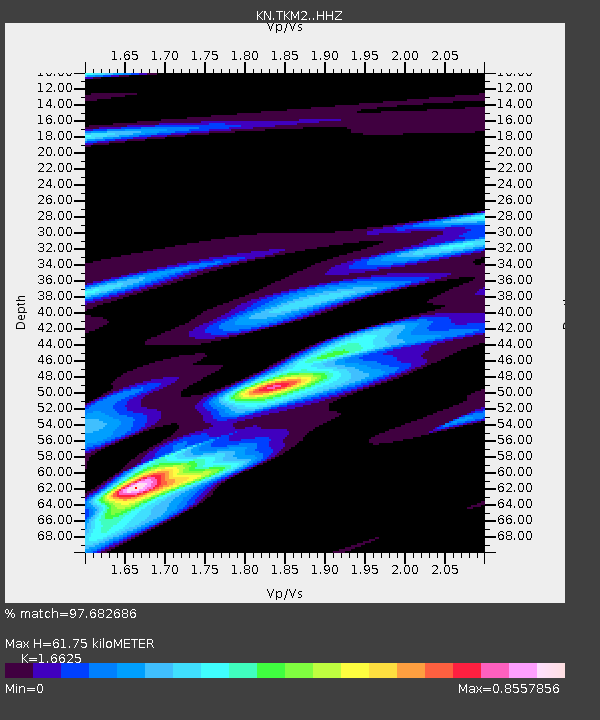
| Estimated Moho Depth: |
61.75 km |
| Estimated Crust Vp/Vs: |
1.66 |
| Assumed Crust Vp: |
6.306 km/s |
| Estimated Crust Vs: |
3.793 km/s |
| Estimated Crust Poisson's Ratio: |
0.22 |
|
| Radial Match: |
97.682686 % |
| Radial Bump: |
253 |
| Transverse Match: |
80.60942 % |
| Transverse Bump: |
400 |
| SOD ConfigId: |
3390531 |
| Insert Time: |
2019-04-15 14:16:01.905 +0000 |
| GWidth: |
2.5 |
| Max Bumps: |
400 |
| Tol: |
0.001 |
|
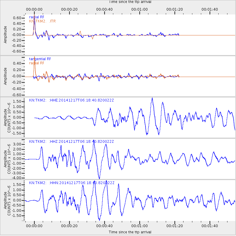
Signal To Noise
| Channel | StoN | STA | LTA |
| KN:TKM2: :HHZ:20141217T06:18:40.820022Z | 12.446829 | 1.0108547E-6 | 8.1213834E-8 |
| KN:TKM2: :HHN:20141217T06:18:40.820022Z | 7.210241 | 4.5201202E-7 | 6.2690276E-8 |
| KN:TKM2: :HHE:20141217T06:18:40.820022Z | 3.304592 | 2.9227664E-7 | 8.844561E-8 |
| Arrivals |
| Ps | 6.9 SECOND |
| PpPs | 25 SECOND |
| PsPs/PpSs | 31 SECOND |


