You are here: Home > Network List > AZ - ANZA Regional Network Stations List
> Station FRD AZ.FRD > Earthquake Result Viewer
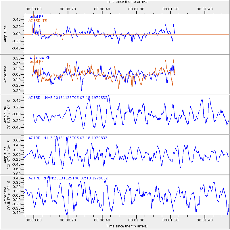
FRD AZ.FRD - Earthquake Result Viewer
*The percent match for this event was below the threshold and hence no stack was calculated.
| Earthquake location: |
Kuril Islands |
| Earthquake latitude/longitude: |
45.6/151.0 |
| Earthquake time(UTC): |
2013/11/25 (329) 05:56:50 GMT |
| Earthquake Depth: |
34 km |
| Earthquake Magnitude: |
6.0 MWW, 5.8 MWB, 6.0 MWC |
| Earthquake Catalog/Contributor: |
NEIC PDE/NEIC COMCAT |
|
| Network: |
AZ ANZA Regional Network |
| Station: |
FRD AZ.FRD |
| Lat/Lon: |
33.49 N/116.60 W |
| Elevation: |
1164 m |
|
| Distance: |
68.5 deg |
| Az: |
63.806 deg |
| Baz: |
311.029 deg |
| Ray Param: |
$rayparam |
*The percent match for this event was below the threshold and hence was not used in the summary stack. |
|
| Radial Match: |
49.989468 % |
| Radial Bump: |
400 |
| Transverse Match: |
48.357502 % |
| Transverse Bump: |
305 |
| SOD ConfigId: |
626651 |
| Insert Time: |
2014-04-19 20:01:44.271 +0000 |
| GWidth: |
2.5 |
| Max Bumps: |
400 |
| Tol: |
0.001 |
|
Signal To Noise
| Channel | StoN | STA | LTA |
| AZ:FRD: :HHZ:20131125T06:07:18.197983Z | 1.0510725 | 1.5786708E-7 | 1.5019619E-7 |
| AZ:FRD: :HHN:20131125T06:07:18.197983Z | 0.82383907 | 1.2970202E-7 | 1.574361E-7 |
| AZ:FRD: :HHE:20131125T06:07:18.197983Z | 3.0805156 | 3.1923912E-7 | 1.0363172E-7 |
| Arrivals |
| Ps | |
| PpPs | |
| PsPs/PpSs | |


