You are here: Home > Network List > XL12 - Hangay Dome, Mongolia Stations List
> Station HV31 HV31 > Earthquake Result Viewer
HV31 HV31 - Earthquake Result Viewer
| Earthquake location: |
Southern Sumatra, Indonesia |
| Earthquake latitude/longitude: |
-3.9/100.1 |
| Earthquake time(UTC): |
2014/12/17 (351) 06:10:05 GMT |
| Earthquake Depth: |
10 km |
| Earthquake Magnitude: |
5.6 MB |
| Earthquake Catalog/Contributor: |
NEIC PDE/NEIC COMCAT |
|
| Network: |
XL Hangay Dome, Mongolia |
| Station: |
HV31 HV31 |
| Lat/Lon: |
51.34 N/100.24 E |
| Elevation: |
1693 m |
|
| Distance: |
55.1 deg |
| Az: |
0.09 deg |
| Baz: |
180.143 deg |
| Ray Param: |
0.06504671 |
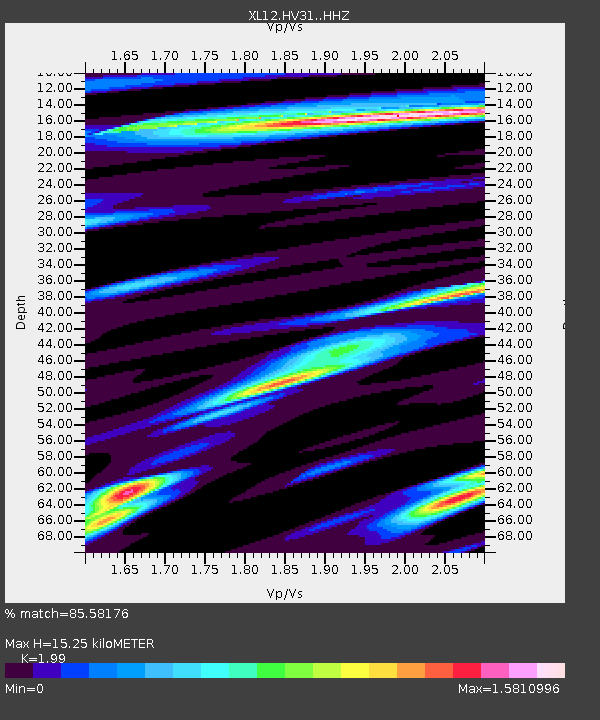
| Estimated Moho Depth: |
15.25 km |
| Estimated Crust Vp/Vs: |
1.99 |
| Assumed Crust Vp: |
6.419 km/s |
| Estimated Crust Vs: |
3.226 km/s |
| Estimated Crust Poisson's Ratio: |
0.33 |
|
| Radial Match: |
85.58176 % |
| Radial Bump: |
400 |
| Transverse Match: |
72.647285 % |
| Transverse Bump: |
400 |
| SOD ConfigId: |
3390531 |
| Insert Time: |
2019-04-15 14:17:27.065 +0000 |
| GWidth: |
2.5 |
| Max Bumps: |
400 |
| Tol: |
0.001 |
|

Signal To Noise
| Channel | StoN | STA | LTA |
| XL:HV31: :HHZ:20141217T06:19:05.729995Z | 7.9019723 | 1.1674845E-6 | 1.4774596E-7 |
| XL:HV31: :HHN:20141217T06:19:05.729995Z | 4.0332637 | 6.585353E-7 | 1.6327604E-7 |
| XL:HV31: :HHE:20141217T06:19:05.729995Z | 1.8094602 | 1.9875726E-7 | 1.09843405E-7 |
| Arrivals |
| Ps | 2.5 SECOND |
| PpPs | 6.8 SECOND |
| PsPs/PpSs | 9.2 SECOND |


