You are here: Home > Network List > YB13 - Continental Dynamics/Cent. Anatolian Tectonics:Surface to Mantle Dynamics During Stations List
> Station AT16 Ekinozu,Maras,Turkey > Earthquake Result Viewer
AT16 Ekinozu,Maras,Turkey - Earthquake Result Viewer
| Earthquake location: |
Southern Sumatra, Indonesia |
| Earthquake latitude/longitude: |
-3.9/100.1 |
| Earthquake time(UTC): |
2014/12/17 (351) 06:10:05 GMT |
| Earthquake Depth: |
10 km |
| Earthquake Magnitude: |
5.6 MB |
| Earthquake Catalog/Contributor: |
NEIC PDE/NEIC COMCAT |
|
| Network: |
YB Continental Dynamics/Cent. Anatolian Tectonics:Surface to Mantle Dynamics During |
| Station: |
AT16 Ekinozu,Maras,Turkey |
| Lat/Lon: |
38.08 N/37.14 E |
| Elevation: |
1279 m |
|
| Distance: |
71.6 deg |
| Az: |
312.189 deg |
| Baz: |
110.485 deg |
| Ray Param: |
0.054220732 |
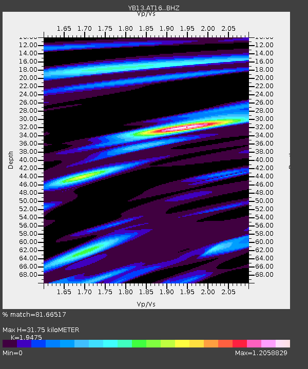
| Estimated Moho Depth: |
31.75 km |
| Estimated Crust Vp/Vs: |
1.95 |
| Assumed Crust Vp: |
6.35 km/s |
| Estimated Crust Vs: |
3.261 km/s |
| Estimated Crust Poisson's Ratio: |
0.32 |
|
| Radial Match: |
81.66517 % |
| Radial Bump: |
400 |
| Transverse Match: |
72.124794 % |
| Transverse Bump: |
400 |
| SOD ConfigId: |
3390531 |
| Insert Time: |
2019-04-15 14:17:37.029 +0000 |
| GWidth: |
2.5 |
| Max Bumps: |
400 |
| Tol: |
0.001 |
|

Signal To Noise
| Channel | StoN | STA | LTA |
| YB:AT16: :BHZ:20141217T06:20:55.500015Z | 3.0257835 | 1.961078E-7 | 6.481224E-8 |
| YB:AT16: :BHN:20141217T06:20:55.500015Z | 0.8788273 | 8.487135E-8 | 9.6573416E-8 |
| YB:AT16: :BHE:20141217T06:20:55.500015Z | 0.59045213 | 5.6251835E-8 | 9.5269094E-8 |
| Arrivals |
| Ps | 4.9 SECOND |
| PpPs | 14 SECOND |
| PsPs/PpSs | 19 SECOND |


