You are here: Home > Network List > TA - USArray Transportable Network (new EarthScope stations) Stations List
> Station POKR Poker Plat Research Range, AK, USA > Earthquake Result Viewer
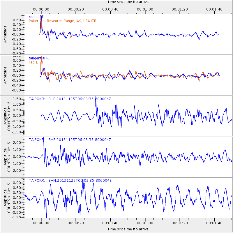
POKR Poker Plat Research Range, AK, USA - Earthquake Result Viewer
*The percent match for this event was below the threshold and hence no stack was calculated.
| Earthquake location: |
Kuril Islands |
| Earthquake latitude/longitude: |
45.6/151.0 |
| Earthquake time(UTC): |
2013/11/25 (329) 05:56:50 GMT |
| Earthquake Depth: |
34 km |
| Earthquake Magnitude: |
6.0 MWW, 5.8 MWB, 6.0 MWC |
| Earthquake Catalog/Contributor: |
NEIC PDE/NEIC COMCAT |
|
| Network: |
TA USArray Transportable Network (new EarthScope stations) |
| Station: |
POKR Poker Plat Research Range, AK, USA |
| Lat/Lon: |
65.12 N/147.43 W |
| Elevation: |
501 m |
|
| Distance: |
38.2 deg |
| Az: |
37.03 deg |
| Baz: |
269.81 deg |
| Ray Param: |
$rayparam |
*The percent match for this event was below the threshold and hence was not used in the summary stack. |
|
| Radial Match: |
72.75855 % |
| Radial Bump: |
358 |
| Transverse Match: |
66.20384 % |
| Transverse Bump: |
400 |
| SOD ConfigId: |
626651 |
| Insert Time: |
2014-04-19 20:24:53.969 +0000 |
| GWidth: |
2.5 |
| Max Bumps: |
400 |
| Tol: |
0.001 |
|
Signal To Noise
| Channel | StoN | STA | LTA |
| TA:POKR: :BHZ:20131125T06:03:35.800004Z | 8.596677 | 8.9895127E-7 | 1.0456962E-7 |
| TA:POKR: :BHN:20131125T06:03:35.800004Z | 2.310348 | 3.992747E-7 | 1.7282017E-7 |
| TA:POKR: :BHE:20131125T06:03:35.800004Z | 2.1651366 | 5.7000466E-7 | 2.6326498E-7 |
| Arrivals |
| Ps | |
| PpPs | |
| PsPs/PpSs | |


