You are here: Home > Network List > TA - USArray Transportable Network (new EarthScope stations) Stations List
> Station Q51A Peebles, OH, USA > Earthquake Result Viewer
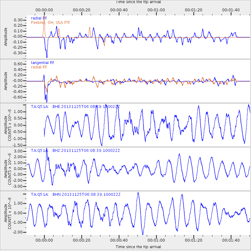
Q51A Peebles, OH, USA - Earthquake Result Viewer
*The percent match for this event was below the threshold and hence no stack was calculated.
| Earthquake location: |
Kuril Islands |
| Earthquake latitude/longitude: |
45.6/151.0 |
| Earthquake time(UTC): |
2013/11/25 (329) 05:56:50 GMT |
| Earthquake Depth: |
34 km |
| Earthquake Magnitude: |
6.0 MWW, 5.8 MWB, 6.0 MWC |
| Earthquake Catalog/Contributor: |
NEIC PDE/NEIC COMCAT |
|
| Network: |
TA USArray Transportable Network (new EarthScope stations) |
| Station: |
Q51A Peebles, OH, USA |
| Lat/Lon: |
39.03 N/83.35 W |
| Elevation: |
362 m |
|
| Distance: |
82.7 deg |
| Az: |
39.654 deg |
| Baz: |
324.861 deg |
| Ray Param: |
$rayparam |
*The percent match for this event was below the threshold and hence was not used in the summary stack. |
|
| Radial Match: |
52.817093 % |
| Radial Bump: |
400 |
| Transverse Match: |
91.04096 % |
| Transverse Bump: |
400 |
| SOD ConfigId: |
626651 |
| Insert Time: |
2014-04-19 20:25:01.786 +0000 |
| GWidth: |
2.5 |
| Max Bumps: |
400 |
| Tol: |
0.001 |
|
Signal To Noise
| Channel | StoN | STA | LTA |
| TA:Q51A: :BHZ:20131125T06:08:39.100022Z | 3.1096697 | 1.8025587E-6 | 5.7966247E-7 |
| TA:Q51A: :BHN:20131125T06:08:39.100022Z | 1.1922947 | 8.11562E-7 | 6.806724E-7 |
| TA:Q51A: :BHE:20131125T06:08:39.100022Z | 1.8334345 | 1.016116E-6 | 5.542145E-7 |
| Arrivals |
| Ps | |
| PpPs | |
| PsPs/PpSs | |


