You are here: Home > Network List > TA - USArray Transportable Network (new EarthScope stations) Stations List
> Station S60A Water View, VA, USA > Earthquake Result Viewer
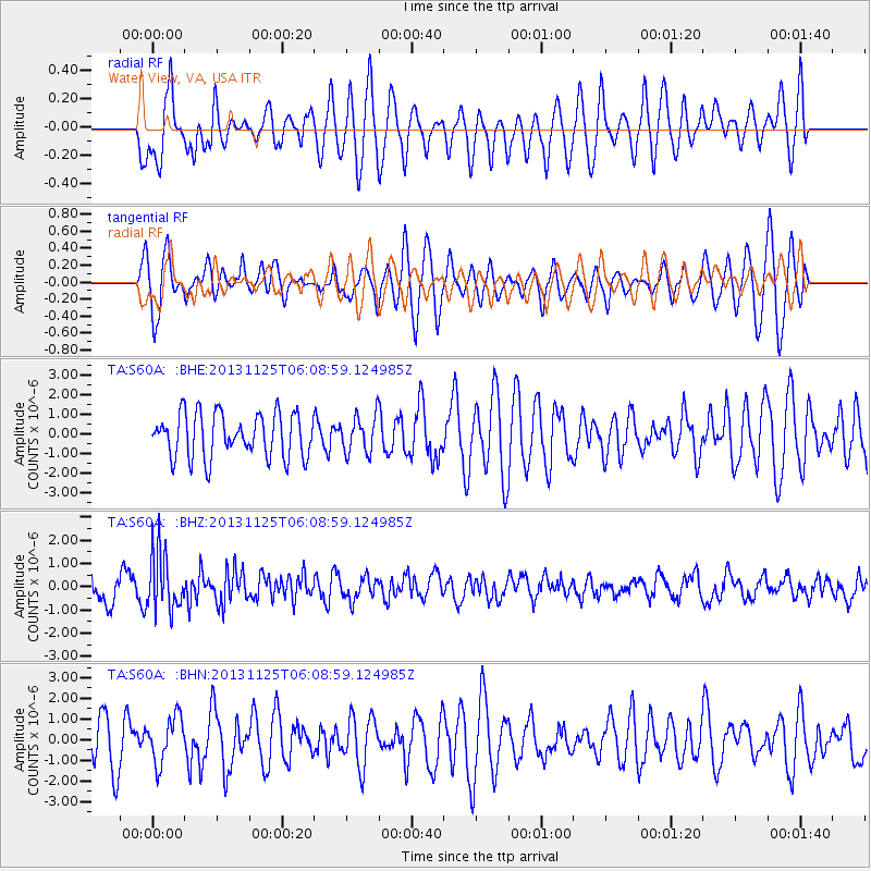
S60A Water View, VA, USA - Earthquake Result Viewer
*The percent match for this event was below the threshold and hence no stack was calculated.
| Earthquake location: |
Kuril Islands |
| Earthquake latitude/longitude: |
45.6/151.0 |
| Earthquake time(UTC): |
2013/11/25 (329) 05:56:50 GMT |
| Earthquake Depth: |
34 km |
| Earthquake Magnitude: |
6.0 MWW, 5.8 MWB, 6.0 MWC |
| Earthquake Catalog/Contributor: |
NEIC PDE/NEIC COMCAT |
|
| Network: |
TA USArray Transportable Network (new EarthScope stations) |
| Station: |
S60A Water View, VA, USA |
| Lat/Lon: |
37.42 N/76.39 W |
| Elevation: |
36 m |
|
| Distance: |
87.0 deg |
| Az: |
35.93 deg |
| Baz: |
328.814 deg |
| Ray Param: |
$rayparam |
*The percent match for this event was below the threshold and hence was not used in the summary stack. |
|
| Radial Match: |
42.432354 % |
| Radial Bump: |
400 |
| Transverse Match: |
61.20583 % |
| Transverse Bump: |
400 |
| SOD ConfigId: |
626651 |
| Insert Time: |
2014-04-19 20:25:46.161 +0000 |
| GWidth: |
2.5 |
| Max Bumps: |
400 |
| Tol: |
0.001 |
|
Signal To Noise
| Channel | StoN | STA | LTA |
| TA:S60A: :BHZ:20131125T06:08:59.124985Z | 1.7716072 | 1.2469173E-6 | 7.0383396E-7 |
| TA:S60A: :BHN:20131125T06:08:59.124985Z | 0.6910856 | 1.1146685E-6 | 1.6129239E-6 |
| TA:S60A: :BHE:20131125T06:08:59.124985Z | 0.8954774 | 1.0161942E-6 | 1.1348072E-6 |
| Arrivals |
| Ps | |
| PpPs | |
| PsPs/PpSs | |


