You are here: Home > Network List > TA - USArray Transportable Network (new EarthScope stations) Stations List
> Station W52A Murphy, NC, USA > Earthquake Result Viewer
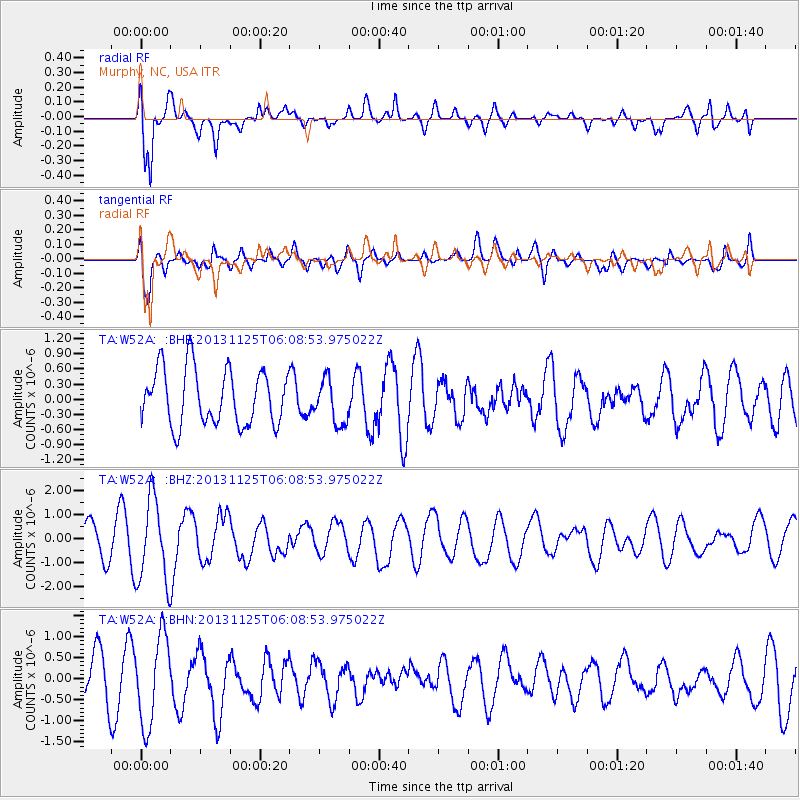
W52A Murphy, NC, USA - Earthquake Result Viewer
*The percent match for this event was below the threshold and hence no stack was calculated.
| Earthquake location: |
Kuril Islands |
| Earthquake latitude/longitude: |
45.6/151.0 |
| Earthquake time(UTC): |
2013/11/25 (329) 05:56:50 GMT |
| Earthquake Depth: |
34 km |
| Earthquake Magnitude: |
6.0 MWW, 5.8 MWB, 6.0 MWC |
| Earthquake Catalog/Contributor: |
NEIC PDE/NEIC COMCAT |
|
| Network: |
TA USArray Transportable Network (new EarthScope stations) |
| Station: |
W52A Murphy, NC, USA |
| Lat/Lon: |
35.09 N/83.93 W |
| Elevation: |
519 m |
|
| Distance: |
85.6 deg |
| Az: |
42.309 deg |
| Baz: |
324.782 deg |
| Ray Param: |
$rayparam |
*The percent match for this event was below the threshold and hence was not used in the summary stack. |
|
| Radial Match: |
70.41397 % |
| Radial Bump: |
400 |
| Transverse Match: |
68.147125 % |
| Transverse Bump: |
400 |
| SOD ConfigId: |
626651 |
| Insert Time: |
2014-04-19 20:26:46.217 +0000 |
| GWidth: |
2.5 |
| Max Bumps: |
400 |
| Tol: |
0.001 |
|
Signal To Noise
| Channel | StoN | STA | LTA |
| TA:W52A: :BHZ:20131125T06:08:53.975022Z | 2.9689217 | 1.7448622E-6 | 5.877091E-7 |
| TA:W52A: :BHN:20131125T06:08:53.975022Z | 1.6637493 | 1.0546813E-6 | 6.3391843E-7 |
| TA:W52A: :BHE:20131125T06:08:53.975022Z | 0.8054024 | 4.3996033E-7 | 5.462615E-7 |
| Arrivals |
| Ps | |
| PpPs | |
| PsPs/PpSs | |


