You are here: Home > Network List > US - United States National Seismic Network Stations List
> Station MSO Missoula, Montana, USA > Earthquake Result Viewer
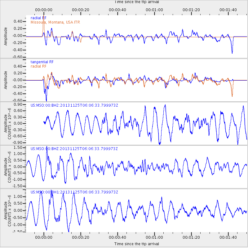
MSO Missoula, Montana, USA - Earthquake Result Viewer
*The percent match for this event was below the threshold and hence no stack was calculated.
| Earthquake location: |
Kuril Islands |
| Earthquake latitude/longitude: |
45.6/151.0 |
| Earthquake time(UTC): |
2013/11/25 (329) 05:56:50 GMT |
| Earthquake Depth: |
34 km |
| Earthquake Magnitude: |
6.0 MWW, 5.8 MWB, 6.0 MWC |
| Earthquake Catalog/Contributor: |
NEIC PDE/NEIC COMCAT |
|
| Network: |
US United States National Seismic Network |
| Station: |
MSO Missoula, Montana, USA |
| Lat/Lon: |
46.83 N/113.94 W |
| Elevation: |
1264 m |
|
| Distance: |
61.6 deg |
| Az: |
51.002 deg |
| Baz: |
307.327 deg |
| Ray Param: |
$rayparam |
*The percent match for this event was below the threshold and hence was not used in the summary stack. |
|
| Radial Match: |
59.3591 % |
| Radial Bump: |
400 |
| Transverse Match: |
76.08216 % |
| Transverse Bump: |
400 |
| SOD ConfigId: |
626651 |
| Insert Time: |
2014-04-19 20:28:46.216 +0000 |
| GWidth: |
2.5 |
| Max Bumps: |
400 |
| Tol: |
0.001 |
|
Signal To Noise
| Channel | StoN | STA | LTA |
| US:MSO:00:BHZ:20131125T06:06:33.799973Z | 1.5870469 | 7.7327275E-7 | 4.8724E-7 |
| US:MSO:00:BH1:20131125T06:06:33.799973Z | 2.5835693 | 9.0791264E-7 | 3.5141795E-7 |
| US:MSO:00:BH2:20131125T06:06:33.799973Z | 0.7659917 | 2.5888588E-7 | 3.379748E-7 |
| Arrivals |
| Ps | |
| PpPs | |
| PsPs/PpSs | |


