You are here: Home > Network List > US - United States National Seismic Network Stations List
> Station WUAZ Wupatki, Arizona, USA > Earthquake Result Viewer
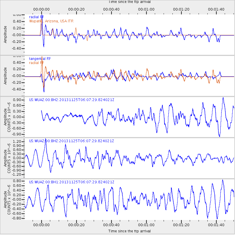
WUAZ Wupatki, Arizona, USA - Earthquake Result Viewer
*The percent match for this event was below the threshold and hence no stack was calculated.
| Earthquake location: |
Kuril Islands |
| Earthquake latitude/longitude: |
45.6/151.0 |
| Earthquake time(UTC): |
2013/11/25 (329) 05:56:50 GMT |
| Earthquake Depth: |
34 km |
| Earthquake Magnitude: |
6.0 MWW, 5.8 MWB, 6.0 MWC |
| Earthquake Catalog/Contributor: |
NEIC PDE/NEIC COMCAT |
|
| Network: |
US United States National Seismic Network |
| Station: |
WUAZ Wupatki, Arizona, USA |
| Lat/Lon: |
35.52 N/111.37 W |
| Elevation: |
1592 m |
|
| Distance: |
70.4 deg |
| Az: |
59.132 deg |
| Baz: |
312.337 deg |
| Ray Param: |
$rayparam |
*The percent match for this event was below the threshold and hence was not used in the summary stack. |
|
| Radial Match: |
62.921757 % |
| Radial Bump: |
400 |
| Transverse Match: |
83.775314 % |
| Transverse Bump: |
400 |
| SOD ConfigId: |
626651 |
| Insert Time: |
2014-04-19 20:29:08.088 +0000 |
| GWidth: |
2.5 |
| Max Bumps: |
400 |
| Tol: |
0.001 |
|
Signal To Noise
| Channel | StoN | STA | LTA |
| US:WUAZ:00:BHZ:20131125T06:07:29.824021Z | 2.8749487 | 6.3385073E-7 | 2.2047375E-7 |
| US:WUAZ:00:BH1:20131125T06:07:29.824021Z | 1.5569038 | 3.4825112E-7 | 2.2368185E-7 |
| US:WUAZ:00:BH2:20131125T06:07:29.824021Z | 2.2985303 | 2.8295594E-7 | 1.2310298E-7 |
| Arrivals |
| Ps | |
| PpPs | |
| PsPs/PpSs | |


