You are here: Home > Network List > UW - Pacific Northwest Regional Seismic Network Stations List
> Station UMAT Pilot Rock, OR, USA > Earthquake Result Viewer
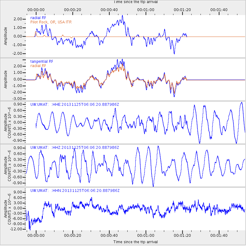
UMAT Pilot Rock, OR, USA - Earthquake Result Viewer
*The percent match for this event was below the threshold and hence no stack was calculated.
| Earthquake location: |
Kuril Islands |
| Earthquake latitude/longitude: |
45.6/151.0 |
| Earthquake time(UTC): |
2013/11/25 (329) 05:56:50 GMT |
| Earthquake Depth: |
34 km |
| Earthquake Magnitude: |
6.0 MWW, 5.8 MWB, 6.0 MWC |
| Earthquake Catalog/Contributor: |
NEIC PDE/NEIC COMCAT |
|
| Network: |
UW Pacific Northwest Regional Seismic Network |
| Station: |
UMAT Pilot Rock, OR, USA |
| Lat/Lon: |
45.29 N/118.96 W |
| Elevation: |
1318 m |
|
| Distance: |
59.8 deg |
| Az: |
54.801 deg |
| Baz: |
305.583 deg |
| Ray Param: |
$rayparam |
*The percent match for this event was below the threshold and hence was not used in the summary stack. |
|
| Radial Match: |
66.72758 % |
| Radial Bump: |
400 |
| Transverse Match: |
66.96917 % |
| Transverse Bump: |
400 |
| SOD ConfigId: |
626651 |
| Insert Time: |
2014-04-19 20:30:14.866 +0000 |
| GWidth: |
2.5 |
| Max Bumps: |
400 |
| Tol: |
0.001 |
|
Signal To Noise
| Channel | StoN | STA | LTA |
| UW:UMAT: :HHZ:20131125T06:06:20.887986Z | 1.6381983 | 5.2779797E-7 | 3.2218196E-7 |
| UW:UMAT: :HHN:20131125T06:06:20.887986Z | 3.0787184 | 8.145974E-6 | 2.6458977E-6 |
| UW:UMAT: :HHE:20131125T06:06:20.887986Z | 0.5206753 | 1.6783811E-7 | 3.2234698E-7 |
| Arrivals |
| Ps | |
| PpPs | |
| PsPs/PpSs | |


