You are here: Home > Network List > BL - Brazilian Lithospheric Seismic Project (BLSP) Stations List
> Station PMNB Patos de Minas, MG > Earthquake Result Viewer
PMNB Patos de Minas, MG - Earthquake Result Viewer
| Earthquake location: |
Falkland Islands Region |
| Earthquake latitude/longitude: |
-53.9/-55.0 |
| Earthquake time(UTC): |
2013/11/25 (329) 06:27:33 GMT |
| Earthquake Depth: |
12 km |
| Earthquake Magnitude: |
7.0 MWW, 6.9 MWC, 6.9 MWB, 7.0 MWC |
| Earthquake Catalog/Contributor: |
NEIC PDE/NEIC COMCAT |
|
| Network: |
BL Brazilian Lithospheric Seismic Project (BLSP) |
| Station: |
PMNB Patos de Minas, MG |
| Lat/Lon: |
18.54 S/46.44 W |
| Elevation: |
950 m |
|
| Distance: |
36.0 deg |
| Az: |
13.923 deg |
| Baz: |
188.623 deg |
| Ray Param: |
0.07694085 |
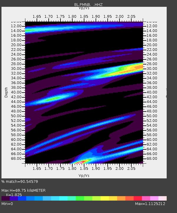
| Estimated Moho Depth: |
69.75 km |
| Estimated Crust Vp/Vs: |
1.83 |
| Assumed Crust Vp: |
6.419 km/s |
| Estimated Crust Vs: |
3.517 km/s |
| Estimated Crust Poisson's Ratio: |
0.29 |
|
| Radial Match: |
90.54579 % |
| Radial Bump: |
217 |
| Transverse Match: |
61.016872 % |
| Transverse Bump: |
400 |
| SOD ConfigId: |
626651 |
| Insert Time: |
2014-04-19 20:32:47.184 +0000 |
| GWidth: |
2.5 |
| Max Bumps: |
400 |
| Tol: |
0.001 |
|

Signal To Noise
| Channel | StoN | STA | LTA |
| BL:PMNB: :HHZ:20131125T06:34:02.879987Z | 2.8358161 | 1.7529086E-6 | 6.18132E-7 |
| BL:PMNB: :HHN:20131125T06:34:02.879987Z | 2.4893062 | 9.94643E-7 | 3.9956632E-7 |
| BL:PMNB: :HHE:20131125T06:34:02.879987Z | 0.40549067 | 1.12243775E-7 | 2.7680977E-7 |
| Arrivals |
| Ps | 9.6 SECOND |
| PpPs | 29 SECOND |
| PsPs/PpSs | 38 SECOND |


