You are here: Home > Network List > G - GEOSCOPE Stations List
> Station FDF Fort de France, Martinique France > Earthquake Result Viewer
FDF Fort de France, Martinique France - Earthquake Result Viewer
| Earthquake location: |
Falkland Islands Region |
| Earthquake latitude/longitude: |
-53.9/-55.0 |
| Earthquake time(UTC): |
2013/11/25 (329) 06:27:33 GMT |
| Earthquake Depth: |
12 km |
| Earthquake Magnitude: |
7.0 MWW, 6.9 MWC, 6.9 MWB, 7.0 MWC |
| Earthquake Catalog/Contributor: |
NEIC PDE/NEIC COMCAT |
|
| Network: |
G GEOSCOPE |
| Station: |
FDF Fort de France, Martinique France |
| Lat/Lon: |
14.73 N/61.14 W |
| Elevation: |
467 m |
|
| Distance: |
68.6 deg |
| Az: |
353.619 deg |
| Baz: |
176.106 deg |
| Ray Param: |
0.05619129 |
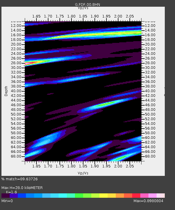
| Estimated Moho Depth: |
28.0 km |
| Estimated Crust Vp/Vs: |
1.60 |
| Assumed Crust Vp: |
5.88 km/s |
| Estimated Crust Vs: |
3.675 km/s |
| Estimated Crust Poisson's Ratio: |
0.18 |
|
| Radial Match: |
89.63726 % |
| Radial Bump: |
400 |
| Transverse Match: |
88.26235 % |
| Transverse Bump: |
400 |
| SOD ConfigId: |
626651 |
| Insert Time: |
2014-04-19 20:33:53.690 +0000 |
| GWidth: |
2.5 |
| Max Bumps: |
400 |
| Tol: |
0.001 |
|
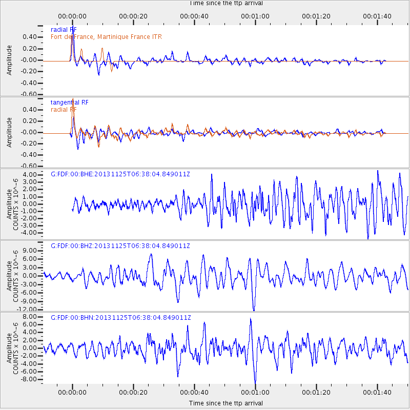
Signal To Noise
| Channel | StoN | STA | LTA |
| G:FDF:00:BHZ:20131125T06:38:04.849011Z | 3.1174173 | 1.7587279E-6 | 5.6416184E-7 |
| G:FDF:00:BHN:20131125T06:38:04.849011Z | 1.9406652 | 1.2848182E-6 | 6.6205035E-7 |
| G:FDF:00:BHE:20131125T06:38:04.849011Z | 1.1977351 | 5.594217E-7 | 4.6706631E-7 |
| Arrivals |
| Ps | 3.0 SECOND |
| PpPs | 12 SECOND |
| PsPs/PpSs | 15 SECOND |


