You are here: Home > Network List > GH - Ghana Digital Seismic Network Stations List
> Station KUKU Kukurantumi, Ghana > Earthquake Result Viewer
KUKU Kukurantumi, Ghana - Earthquake Result Viewer
| Earthquake location: |
Falkland Islands Region |
| Earthquake latitude/longitude: |
-53.9/-55.0 |
| Earthquake time(UTC): |
2013/11/25 (329) 06:27:33 GMT |
| Earthquake Depth: |
12 km |
| Earthquake Magnitude: |
7.0 MWW, 6.9 MWC, 6.9 MWB, 7.0 MWC |
| Earthquake Catalog/Contributor: |
NEIC PDE/NEIC COMCAT |
|
| Network: |
GH Ghana Digital Seismic Network |
| Station: |
KUKU Kukurantumi, Ghana |
| Lat/Lon: |
6.19 N/0.37 W |
| Elevation: |
240 m |
|
| Distance: |
75.3 deg |
| Az: |
56.952 deg |
| Baz: |
209.893 deg |
| Ray Param: |
0.051758703 |
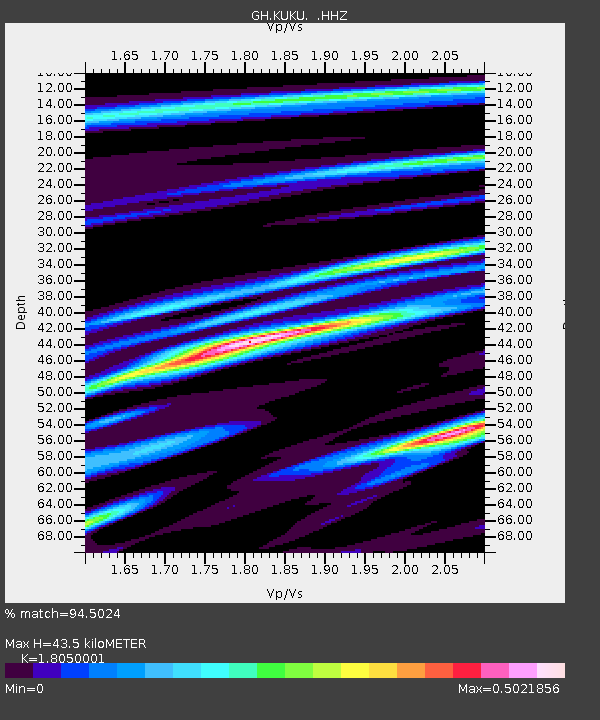
| Estimated Moho Depth: |
43.5 km |
| Estimated Crust Vp/Vs: |
1.81 |
| Assumed Crust Vp: |
6.419 km/s |
| Estimated Crust Vs: |
3.556 km/s |
| Estimated Crust Poisson's Ratio: |
0.28 |
|
| Radial Match: |
94.5024 % |
| Radial Bump: |
294 |
| Transverse Match: |
79.279945 % |
| Transverse Bump: |
400 |
| SOD ConfigId: |
626651 |
| Insert Time: |
2014-04-19 20:34:16.430 +0000 |
| GWidth: |
2.5 |
| Max Bumps: |
400 |
| Tol: |
0.001 |
|

Signal To Noise
| Channel | StoN | STA | LTA |
| GH:KUKU: :HHZ:20131125T06:38:44.880017Z | 1.7578728 | 4.6851773E-7 | 2.665254E-7 |
| GH:KUKU: :HHN:20131125T06:38:44.880017Z | 2.4240446 | 2.7319808E-7 | 1.12703404E-7 |
| GH:KUKU: :HHE:20131125T06:38:44.880017Z | 1.4077517 | 1.1482685E-7 | 8.156754E-8 |
| Arrivals |
| Ps | 5.6 SECOND |
| PpPs | 18 SECOND |
| PsPs/PpSs | 24 SECOND |


