You are here: Home > Network List > TA - USArray Transportable Network (new EarthScope stations) Stations List
> Station W56A Indian Trail, NC, USA > Earthquake Result Viewer
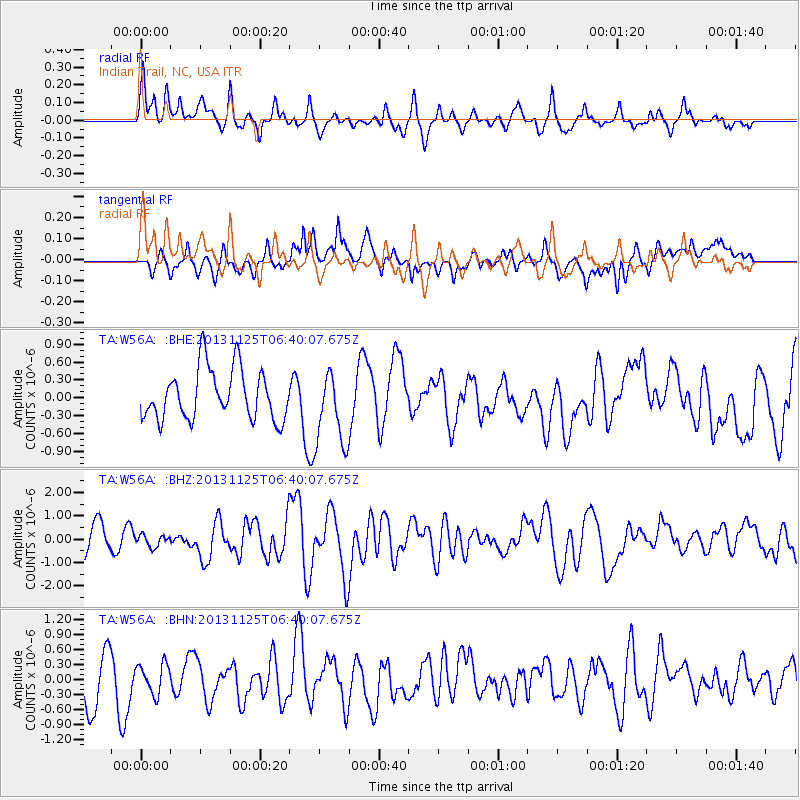
W56A Indian Trail, NC, USA - Earthquake Result Viewer
*The percent match for this event was below the threshold and hence no stack was calculated.
| Earthquake location: |
Falkland Islands Region |
| Earthquake latitude/longitude: |
-53.9/-55.0 |
| Earthquake time(UTC): |
2013/11/25 (329) 06:27:33 GMT |
| Earthquake Depth: |
12 km |
| Earthquake Magnitude: |
7.0 MWW, 6.9 MWC, 6.9 MWB, 7.0 MWC |
| Earthquake Catalog/Contributor: |
NEIC PDE/NEIC COMCAT |
|
| Network: |
TA USArray Transportable Network (new EarthScope stations) |
| Station: |
W56A Indian Trail, NC, USA |
| Lat/Lon: |
35.13 N/80.58 W |
| Elevation: |
177 m |
|
| Distance: |
91.4 deg |
| Az: |
339.268 deg |
| Baz: |
165.208 deg |
| Ray Param: |
$rayparam |
*The percent match for this event was below the threshold and hence was not used in the summary stack. |
|
| Radial Match: |
62.35863 % |
| Radial Bump: |
400 |
| Transverse Match: |
52.576466 % |
| Transverse Bump: |
400 |
| SOD ConfigId: |
626651 |
| Insert Time: |
2014-04-19 20:42:52.300 +0000 |
| GWidth: |
2.5 |
| Max Bumps: |
400 |
| Tol: |
0.001 |
|
Signal To Noise
| Channel | StoN | STA | LTA |
| TA:W56A: :BHZ:20131125T06:40:07.675Z | 0.6129336 | 2.5677653E-7 | 4.1893043E-7 |
| TA:W56A: :BHN:20131125T06:40:07.675Z | 0.67738193 | 3.0543862E-7 | 4.5091045E-7 |
| TA:W56A: :BHE:20131125T06:40:07.675Z | 1.5097924 | 6.404055E-7 | 4.2416792E-7 |
| Arrivals |
| Ps | |
| PpPs | |
| PsPs/PpSs | |


