You are here: Home > Network List > WI - West Indies IPGP Network Stations List
> Station BIM Morne Bigot, Anses d'Arlets, Martinique > Earthquake Result Viewer
BIM Morne Bigot, Anses d'Arlets, Martinique - Earthquake Result Viewer
| Earthquake location: |
Falkland Islands Region |
| Earthquake latitude/longitude: |
-53.9/-55.0 |
| Earthquake time(UTC): |
2013/11/25 (329) 06:27:33 GMT |
| Earthquake Depth: |
12 km |
| Earthquake Magnitude: |
7.0 MWW, 6.9 MWC, 6.9 MWB, 7.0 MWC |
| Earthquake Catalog/Contributor: |
NEIC PDE/NEIC COMCAT |
|
| Network: |
WI West Indies IPGP Network |
| Station: |
BIM Morne Bigot, Anses d'Arlets, Martinique |
| Lat/Lon: |
14.52 N/61.07 W |
| Elevation: |
391 m |
|
| Distance: |
68.4 deg |
| Az: |
353.683 deg |
| Baz: |
176.149 deg |
| Ray Param: |
0.05633539 |
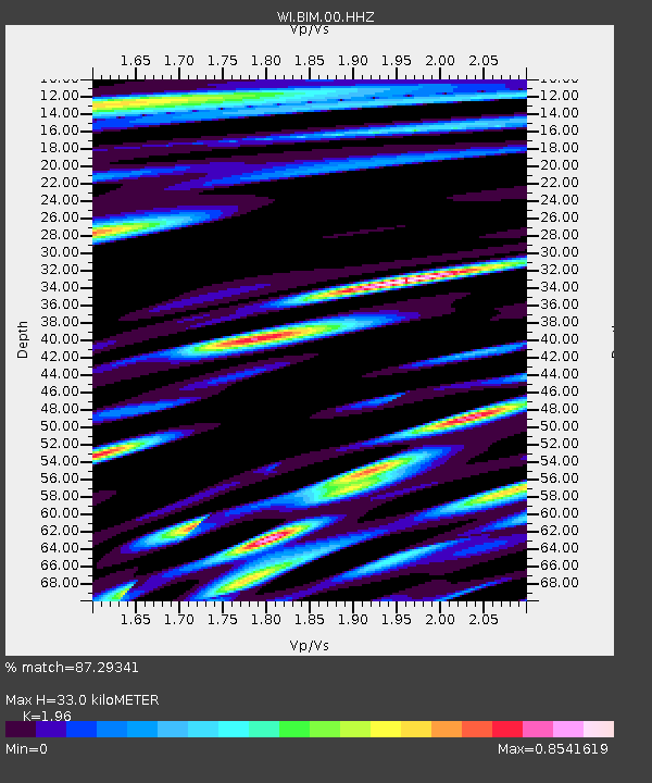
| Estimated Moho Depth: |
33.0 km |
| Estimated Crust Vp/Vs: |
1.96 |
| Assumed Crust Vp: |
5.88 km/s |
| Estimated Crust Vs: |
3.0 km/s |
| Estimated Crust Poisson's Ratio: |
0.32 |
|
| Radial Match: |
87.29341 % |
| Radial Bump: |
400 |
| Transverse Match: |
79.296165 % |
| Transverse Bump: |
400 |
| SOD ConfigId: |
626651 |
| Insert Time: |
2014-04-19 20:43:57.682 +0000 |
| GWidth: |
2.5 |
| Max Bumps: |
400 |
| Tol: |
0.001 |
|

Signal To Noise
| Channel | StoN | STA | LTA |
| WI:BIM:00:HHZ:20131125T06:38:03.440015Z | 2.2437527 | 1.3026932E-6 | 5.805868E-7 |
| WI:BIM:00:HHN:20131125T06:38:03.440015Z | 1.1467298 | 8.365921E-7 | 7.2954595E-7 |
| WI:BIM:00:HHE:20131125T06:38:03.440015Z | 0.88991874 | 6.727239E-7 | 7.559386E-7 |
| Arrivals |
| Ps | 5.5 SECOND |
| PpPs | 16 SECOND |
| PsPs/PpSs | 22 SECOND |


