You are here: Home > Network List > WI - West Indies IPGP Network Stations List
> Station MPOM Morne Pois, Sainte-Anne, Martinique > Earthquake Result Viewer
MPOM Morne Pois, Sainte-Anne, Martinique - Earthquake Result Viewer
| Earthquake location: |
Falkland Islands Region |
| Earthquake latitude/longitude: |
-53.9/-55.0 |
| Earthquake time(UTC): |
2013/11/25 (329) 06:27:33 GMT |
| Earthquake Depth: |
12 km |
| Earthquake Magnitude: |
7.0 MWW, 6.9 MWC, 6.9 MWB, 7.0 MWC |
| Earthquake Catalog/Contributor: |
NEIC PDE/NEIC COMCAT |
|
| Network: |
WI West Indies IPGP Network |
| Station: |
MPOM Morne Pois, Sainte-Anne, Martinique |
| Lat/Lon: |
14.45 N/60.86 W |
| Elevation: |
50 m |
|
| Distance: |
68.3 deg |
| Az: |
353.894 deg |
| Baz: |
176.278 deg |
| Ray Param: |
0.056390136 |
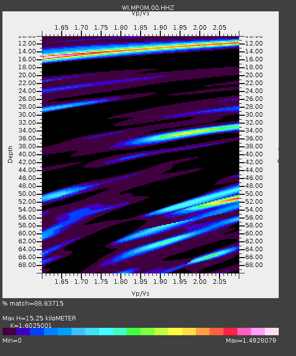
| Estimated Moho Depth: |
15.25 km |
| Estimated Crust Vp/Vs: |
1.60 |
| Assumed Crust Vp: |
5.88 km/s |
| Estimated Crust Vs: |
3.67 km/s |
| Estimated Crust Poisson's Ratio: |
0.18 |
|
| Radial Match: |
88.63715 % |
| Radial Bump: |
368 |
| Transverse Match: |
76.37545 % |
| Transverse Bump: |
400 |
| SOD ConfigId: |
626651 |
| Insert Time: |
2014-04-19 20:44:08.869 +0000 |
| GWidth: |
2.5 |
| Max Bumps: |
400 |
| Tol: |
0.001 |
|

Signal To Noise
| Channel | StoN | STA | LTA |
| WI:MPOM:00:HHZ:20131125T06:38:02.930005Z | 2.5297348 | 1.3935462E-6 | 5.508665E-7 |
| WI:MPOM:00:HHN:20131125T06:38:02.930005Z | 1.1656598 | 6.649571E-7 | 5.704556E-7 |
| WI:MPOM:00:HHE:20131125T06:38:02.930005Z | 1.0318576 | 5.1886764E-7 | 5.0284814E-7 |
| Arrivals |
| Ps | 1.6 SECOND |
| PpPs | 6.5 SECOND |
| PsPs/PpSs | 8.1 SECOND |


