You are here: Home > Network List > TA - USArray Transportable Network (new EarthScope stations) Stations List
> Station K63A Dunstable, MA, USA > Earthquake Result Viewer
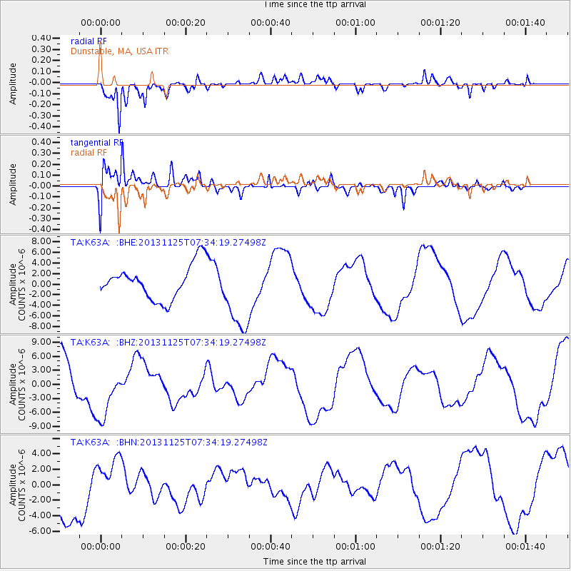
K63A Dunstable, MA, USA - Earthquake Result Viewer
*The percent match for this event was below the threshold and hence no stack was calculated.
| Earthquake location: |
South Atlantic Ocean |
| Earthquake latitude/longitude: |
-53.9/-53.9 |
| Earthquake time(UTC): |
2013/11/25 (329) 07:21:18 GMT |
| Earthquake Depth: |
15 km |
| Earthquake Magnitude: |
6.0 MWC, 6.0 MWC |
| Earthquake Catalog/Contributor: |
NEIC PDE/NEIC COMCAT |
|
| Network: |
TA USArray Transportable Network (new EarthScope stations) |
| Station: |
K63A Dunstable, MA, USA |
| Lat/Lon: |
42.69 N/71.53 W |
| Elevation: |
68 m |
|
| Distance: |
97.4 deg |
| Az: |
346.996 deg |
| Baz: |
169.588 deg |
| Ray Param: |
$rayparam |
*The percent match for this event was below the threshold and hence was not used in the summary stack. |
|
| Radial Match: |
87.55219 % |
| Radial Bump: |
400 |
| Transverse Match: |
85.577705 % |
| Transverse Bump: |
400 |
| SOD ConfigId: |
626651 |
| Insert Time: |
2014-04-19 20:50:49.257 +0000 |
| GWidth: |
2.5 |
| Max Bumps: |
400 |
| Tol: |
0.001 |
|
Signal To Noise
| Channel | StoN | STA | LTA |
| TA:K63A: :BHZ:20131125T07:34:19.27498Z | 1.0621866 | 6.077091E-6 | 5.7213024E-6 |
| TA:K63A: :BHN:20131125T07:34:19.27498Z | 0.67275083 | 3.321199E-6 | 4.9367445E-6 |
| TA:K63A: :BHE:20131125T07:34:19.27498Z | 2.211083 | 7.1370196E-6 | 3.2278388E-6 |
| Arrivals |
| Ps | |
| PpPs | |
| PsPs/PpSs | |


