You are here: Home > Network List > TA - USArray Transportable Network (new EarthScope stations) Stations List
> Station P50A Jamestown, OH, USA > Earthquake Result Viewer
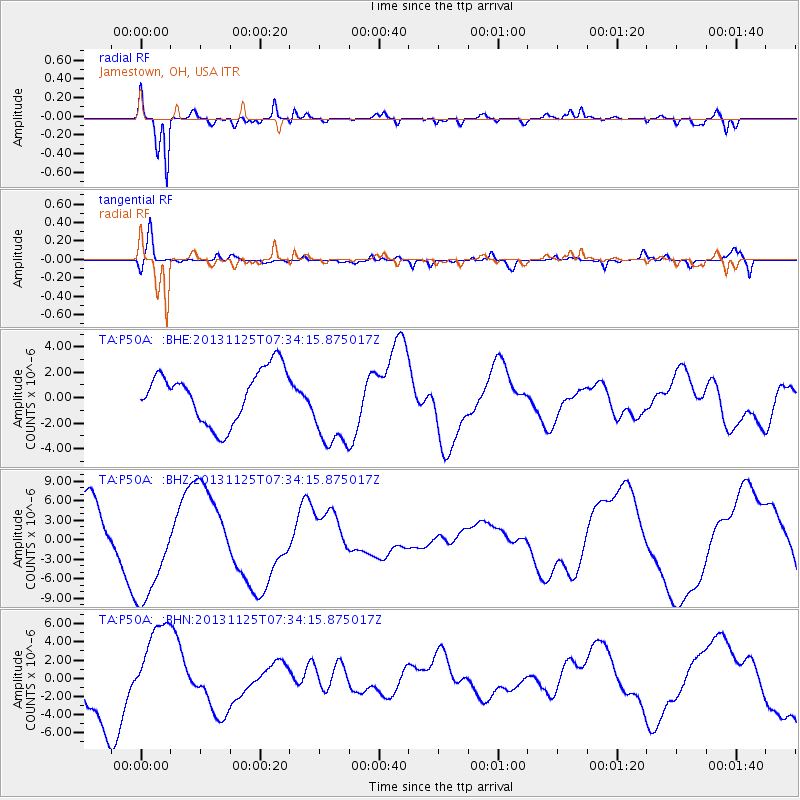
P50A Jamestown, OH, USA - Earthquake Result Viewer
*The percent match for this event was below the threshold and hence no stack was calculated.
| Earthquake location: |
South Atlantic Ocean |
| Earthquake latitude/longitude: |
-53.9/-53.9 |
| Earthquake time(UTC): |
2013/11/25 (329) 07:21:18 GMT |
| Earthquake Depth: |
15 km |
| Earthquake Magnitude: |
6.0 MWC, 6.0 MWC |
| Earthquake Catalog/Contributor: |
NEIC PDE/NEIC COMCAT |
|
| Network: |
TA USArray Transportable Network (new EarthScope stations) |
| Station: |
P50A Jamestown, OH, USA |
| Lat/Lon: |
39.61 N/83.80 W |
| Elevation: |
318 m |
|
| Distance: |
96.6 deg |
| Az: |
337.2 deg |
| Baz: |
162.719 deg |
| Ray Param: |
$rayparam |
*The percent match for this event was below the threshold and hence was not used in the summary stack. |
|
| Radial Match: |
94.76236 % |
| Radial Bump: |
393 |
| Transverse Match: |
80.60875 % |
| Transverse Bump: |
400 |
| SOD ConfigId: |
626651 |
| Insert Time: |
2014-04-19 20:52:05.304 +0000 |
| GWidth: |
2.5 |
| Max Bumps: |
400 |
| Tol: |
0.001 |
|
Signal To Noise
| Channel | StoN | STA | LTA |
| TA:P50A: :BHZ:20131125T07:34:15.875017Z | 1.8966913 | 8.079141E-6 | 4.259597E-6 |
| TA:P50A: :BHN:20131125T07:34:15.875017Z | 1.4819663 | 4.612939E-6 | 3.1127151E-6 |
| TA:P50A: :BHE:20131125T07:34:15.875017Z | 1.7142327 | 3.4974344E-6 | 2.040233E-6 |
| Arrivals |
| Ps | |
| PpPs | |
| PsPs/PpSs | |


