You are here: Home > Network List > TA - USArray Transportable Network (new EarthScope stations) Stations List
> Station W52A Murphy, NC, USA > Earthquake Result Viewer
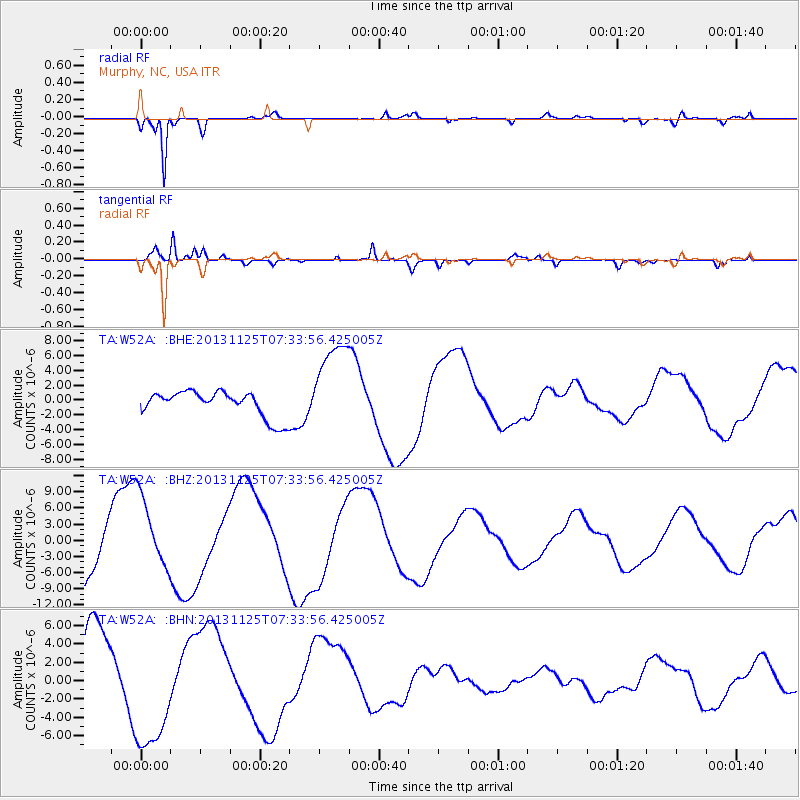
W52A Murphy, NC, USA - Earthquake Result Viewer
*The percent match for this event was below the threshold and hence no stack was calculated.
| Earthquake location: |
South Atlantic Ocean |
| Earthquake latitude/longitude: |
-53.9/-53.9 |
| Earthquake time(UTC): |
2013/11/25 (329) 07:21:18 GMT |
| Earthquake Depth: |
15 km |
| Earthquake Magnitude: |
6.0 MWC, 6.0 MWC |
| Earthquake Catalog/Contributor: |
NEIC PDE/NEIC COMCAT |
|
| Network: |
TA USArray Transportable Network (new EarthScope stations) |
| Station: |
W52A Murphy, NC, USA |
| Lat/Lon: |
35.09 N/83.93 W |
| Elevation: |
519 m |
|
| Distance: |
92.3 deg |
| Az: |
335.76 deg |
| Baz: |
162.753 deg |
| Ray Param: |
$rayparam |
*The percent match for this event was below the threshold and hence was not used in the summary stack. |
|
| Radial Match: |
94.2346 % |
| Radial Bump: |
274 |
| Transverse Match: |
71.611435 % |
| Transverse Bump: |
400 |
| SOD ConfigId: |
626651 |
| Insert Time: |
2014-04-19 20:53:43.841 +0000 |
| GWidth: |
2.5 |
| Max Bumps: |
400 |
| Tol: |
0.001 |
|
Signal To Noise
| Channel | StoN | STA | LTA |
| TA:W52A: :BHZ:20131125T07:33:56.425005Z | 1.2541982 | 6.979513E-6 | 5.5649202E-6 |
| TA:W52A: :BHN:20131125T07:33:56.425005Z | 1.855984 | 6.8340305E-6 | 3.6821602E-6 |
| TA:W52A: :BHE:20131125T07:33:56.425005Z | 3.62373 | 6.3461803E-6 | 1.751284E-6 |
| Arrivals |
| Ps | |
| PpPs | |
| PsPs/PpSs | |


