You are here: Home > Network List > AK - Alaska Regional Network Stations List
> Station MDM Murphy Dome > Earthquake Result Viewer
MDM Murphy Dome - Earthquake Result Viewer
*The percent match for this event was below the threshold and hence no stack was calculated.
| Earthquake location: |
Near Coast Of Peru |
| Earthquake latitude/longitude: |
-12.6/-76.2 |
| Earthquake time(UTC): |
2013/11/25 (329) 20:06:55 GMT |
| Earthquake Depth: |
77 km |
| Earthquake Magnitude: |
5.5 MWB, 5.5 MWC |
| Earthquake Catalog/Contributor: |
NEIC PDE/NEIC COMCAT |
|
| Network: |
AK Alaska Regional Network |
| Station: |
MDM Murphy Dome |
| Lat/Lon: |
64.96 N/148.23 W |
| Elevation: |
634 m |
|
| Distance: |
93.9 deg |
| Az: |
336.06 deg |
| Baz: |
111.45 deg |
| Ray Param: |
$rayparam |
*The percent match for this event was below the threshold and hence was not used in the summary stack. |
|
| Radial Match: |
56.59596 % |
| Radial Bump: |
400 |
| Transverse Match: |
56.111237 % |
| Transverse Bump: |
343 |
| SOD ConfigId: |
626651 |
| Insert Time: |
2014-04-19 20:56:16.413 +0000 |
| GWidth: |
2.5 |
| Max Bumps: |
400 |
| Tol: |
0.001 |
|
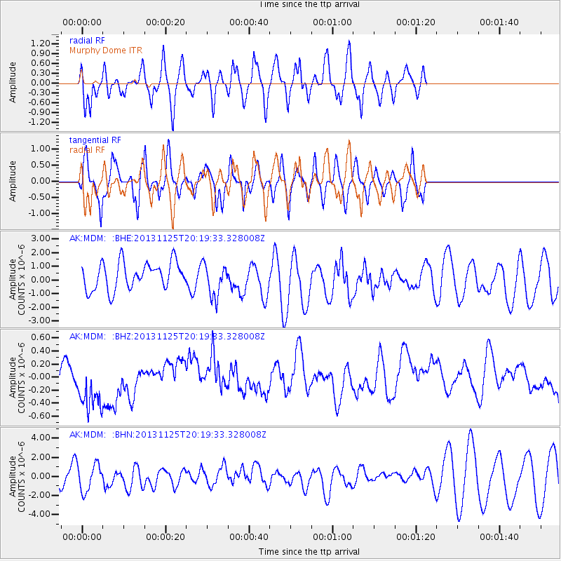
Signal To Noise
| Channel | StoN | STA | LTA |
| AK:MDM: :BHZ:20131125T20:19:33.328008Z | 1.6117249 | 5.0129006E-7 | 3.1102704E-7 |
| AK:MDM: :BHN:20131125T20:19:33.328008Z | 1.1163354 | 1.3972997E-6 | 1.2516845E-6 |
| AK:MDM: :BHE:20131125T20:19:33.328008Z | 1.244838 | 1.2268519E-6 | 9.855513E-7 |
| Arrivals |
| Ps | |
| PpPs | |
| PsPs/PpSs | |


