You are here: Home > Network List > II - Global Seismograph Network (GSN - IRIS/IDA) Stations List
> Station CMLA Cha de Macela, Sao Miguel Island, Azores > Earthquake Result Viewer
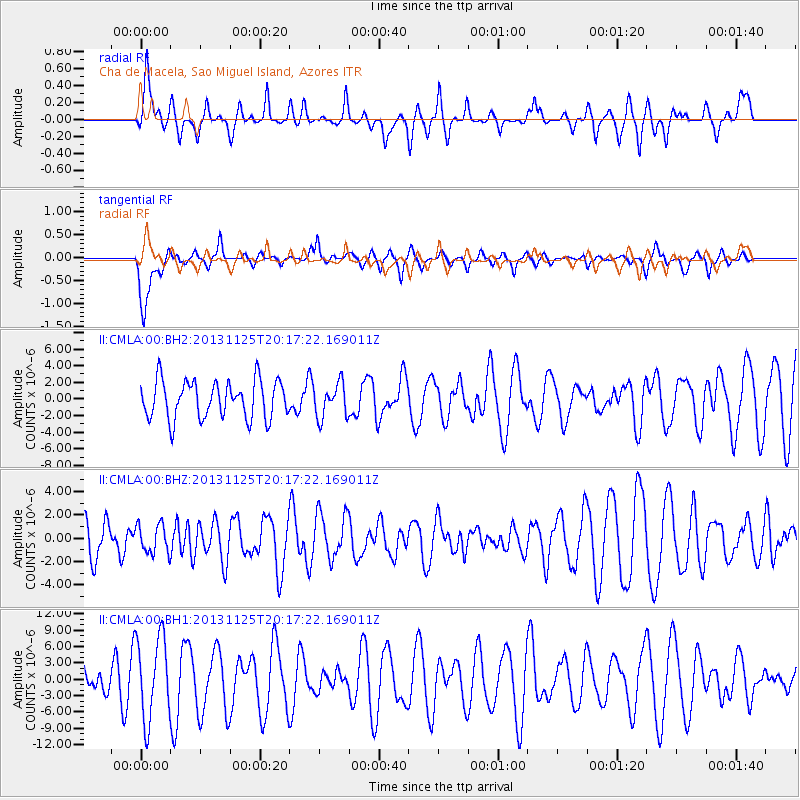
CMLA Cha de Macela, Sao Miguel Island, Azores - Earthquake Result Viewer
*The percent match for this event was below the threshold and hence no stack was calculated.
| Earthquake location: |
Near Coast Of Peru |
| Earthquake latitude/longitude: |
-12.6/-76.2 |
| Earthquake time(UTC): |
2013/11/25 (329) 20:06:55 GMT |
| Earthquake Depth: |
77 km |
| Earthquake Magnitude: |
5.5 MWB, 5.5 MWC |
| Earthquake Catalog/Contributor: |
NEIC PDE/NEIC COMCAT |
|
| Network: |
II Global Seismograph Network (GSN - IRIS/IDA) |
| Station: |
CMLA Cha de Macela, Sao Miguel Island, Azores |
| Lat/Lon: |
37.76 N/25.52 W |
| Elevation: |
429 m |
|
| Distance: |
69.0 deg |
| Az: |
41.044 deg |
| Baz: |
233.984 deg |
| Ray Param: |
$rayparam |
*The percent match for this event was below the threshold and hence was not used in the summary stack. |
|
| Radial Match: |
41.17883 % |
| Radial Bump: |
323 |
| Transverse Match: |
51.761642 % |
| Transverse Bump: |
355 |
| SOD ConfigId: |
626651 |
| Insert Time: |
2014-04-19 21:03:08.063 +0000 |
| GWidth: |
2.5 |
| Max Bumps: |
400 |
| Tol: |
0.001 |
|
Signal To Noise
| Channel | StoN | STA | LTA |
| II:CMLA:00:BHZ:20131125T20:17:22.169011Z | 0.77853364 | 1.234463E-6 | 1.5856258E-6 |
| II:CMLA:00:BH1:20131125T20:17:22.169011Z | 2.810458 | 7.595565E-6 | 2.7026076E-6 |
| II:CMLA:00:BH2:20131125T20:17:22.169011Z | 0.9077649 | 2.0536477E-6 | 2.2623124E-6 |
| Arrivals |
| Ps | |
| PpPs | |
| PsPs/PpSs | |


