You are here: Home > Network List > TA - USArray Transportable Network (new EarthScope stations) Stations List
> Station M61A Granite Springs, NY, USA > Earthquake Result Viewer
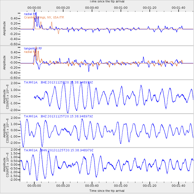
M61A Granite Springs, NY, USA - Earthquake Result Viewer
*The percent match for this event was below the threshold and hence no stack was calculated.
| Earthquake location: |
Near Coast Of Peru |
| Earthquake latitude/longitude: |
-12.6/-76.2 |
| Earthquake time(UTC): |
2013/11/25 (329) 20:06:55 GMT |
| Earthquake Depth: |
77 km |
| Earthquake Magnitude: |
5.5 MWB, 5.5 MWC |
| Earthquake Catalog/Contributor: |
NEIC PDE/NEIC COMCAT |
|
| Network: |
TA USArray Transportable Network (new EarthScope stations) |
| Station: |
M61A Granite Springs, NY, USA |
| Lat/Lon: |
41.31 N/73.77 W |
| Elevation: |
190 m |
|
| Distance: |
53.7 deg |
| Az: |
2.277 deg |
| Baz: |
182.951 deg |
| Ray Param: |
$rayparam |
*The percent match for this event was below the threshold and hence was not used in the summary stack. |
|
| Radial Match: |
64.918106 % |
| Radial Bump: |
400 |
| Transverse Match: |
64.48648 % |
| Transverse Bump: |
338 |
| SOD ConfigId: |
626651 |
| Insert Time: |
2014-04-19 21:13:50.550 +0000 |
| GWidth: |
2.5 |
| Max Bumps: |
400 |
| Tol: |
0.001 |
|
Signal To Noise
| Channel | StoN | STA | LTA |
| TA:M61A: :BHZ:20131125T20:15:38.948979Z | 0.7153216 | 8.634838E-7 | 1.2071267E-6 |
| TA:M61A: :BHN:20131125T20:15:38.948979Z | 2.2971904 | 1.3684404E-6 | 5.957018E-7 |
| TA:M61A: :BHE:20131125T20:15:38.948979Z | 1.4129454 | 1.4879173E-6 | 1.0530607E-6 |
| Arrivals |
| Ps | |
| PpPs | |
| PsPs/PpSs | |


