You are here: Home > Network List > TA - USArray Transportable Network (new EarthScope stations) Stations List
> Station O03E Paynes Creek, CA, USA > Earthquake Result Viewer
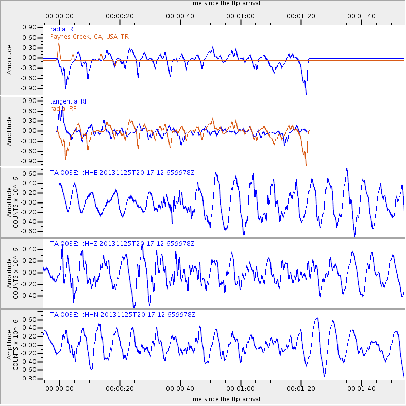
O03E Paynes Creek, CA, USA - Earthquake Result Viewer
*The percent match for this event was below the threshold and hence no stack was calculated.
| Earthquake location: |
Near Coast Of Peru |
| Earthquake latitude/longitude: |
-12.6/-76.2 |
| Earthquake time(UTC): |
2013/11/25 (329) 20:06:55 GMT |
| Earthquake Depth: |
77 km |
| Earthquake Magnitude: |
5.5 MWB, 5.5 MWC |
| Earthquake Catalog/Contributor: |
NEIC PDE/NEIC COMCAT |
|
| Network: |
TA USArray Transportable Network (new EarthScope stations) |
| Station: |
O03E Paynes Creek, CA, USA |
| Lat/Lon: |
40.29 N/121.80 W |
| Elevation: |
967 m |
|
| Distance: |
67.5 deg |
| Az: |
323.734 deg |
| Baz: |
130.975 deg |
| Ray Param: |
$rayparam |
*The percent match for this event was below the threshold and hence was not used in the summary stack. |
|
| Radial Match: |
60.287857 % |
| Radial Bump: |
400 |
| Transverse Match: |
72.92864 % |
| Transverse Bump: |
369 |
| SOD ConfigId: |
626651 |
| Insert Time: |
2014-04-19 21:14:22.293 +0000 |
| GWidth: |
2.5 |
| Max Bumps: |
400 |
| Tol: |
0.001 |
|
Signal To Noise
| Channel | StoN | STA | LTA |
| TA:O03E: :HHZ:20131125T20:17:12.659978Z | 1.7530138 | 2.1057733E-7 | 1.2012302E-7 |
| TA:O03E: :HHN:20131125T20:17:12.659978Z | 0.8999644 | 2.1605972E-7 | 2.4007585E-7 |
| TA:O03E: :HHE:20131125T20:17:12.659978Z | 0.7261091 | 1.2956122E-7 | 1.7843217E-7 |
| Arrivals |
| Ps | |
| PpPs | |
| PsPs/PpSs | |


