You are here: Home > Network List > UW - Pacific Northwest Regional Seismic Network Stations List
> Station PASS Maple Falls, WA, USA > Earthquake Result Viewer
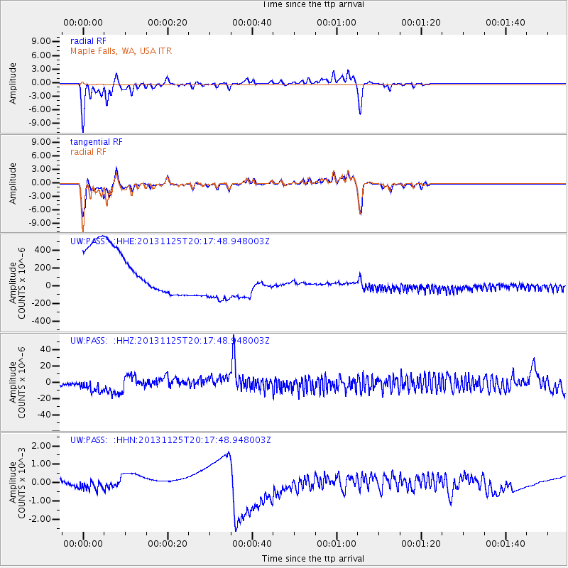
PASS Maple Falls, WA, USA - Earthquake Result Viewer
*The percent match for this event was below the threshold and hence no stack was calculated.
| Earthquake location: |
Near Coast Of Peru |
| Earthquake latitude/longitude: |
-12.6/-76.2 |
| Earthquake time(UTC): |
2013/11/25 (329) 20:06:55 GMT |
| Earthquake Depth: |
77 km |
| Earthquake Magnitude: |
5.5 MWB, 5.5 MWC |
| Earthquake Catalog/Contributor: |
NEIC PDE/NEIC COMCAT |
|
| Network: |
UW Pacific Northwest Regional Seismic Network |
| Station: |
PASS Maple Falls, WA, USA |
| Lat/Lon: |
49.00 N/122.09 W |
| Elevation: |
174 m |
|
| Distance: |
73.5 deg |
| Az: |
330.45 deg |
| Baz: |
133.025 deg |
| Ray Param: |
$rayparam |
*The percent match for this event was below the threshold and hence was not used in the summary stack. |
|
| Radial Match: |
95.626274 % |
| Radial Bump: |
263 |
| Transverse Match: |
89.121544 % |
| Transverse Bump: |
288 |
| SOD ConfigId: |
626651 |
| Insert Time: |
2014-04-19 21:19:44.951 +0000 |
| GWidth: |
2.5 |
| Max Bumps: |
400 |
| Tol: |
0.001 |
|
Signal To Noise
| Channel | StoN | STA | LTA |
| UW:PASS: :HHZ:20131125T20:17:48.948003Z | 0.26806113 | 2.4623696E-5 | 9.185851E-5 |
| UW:PASS: :HHN:20131125T20:17:48.948003Z | 0.35221565 | 4.8536801E-4 | 0.0013780422 |
| UW:PASS: :HHE:20131125T20:17:48.948003Z | 1.3458985 | 3.3504536E-4 | 2.4893807E-4 |
| Arrivals |
| Ps | |
| PpPs | |
| PsPs/PpSs | |


