You are here: Home > Network List > TA - USArray Transportable Network (new EarthScope stations) Stations List
> Station L04D Klamath Falls, OR, USA > Earthquake Result Viewer
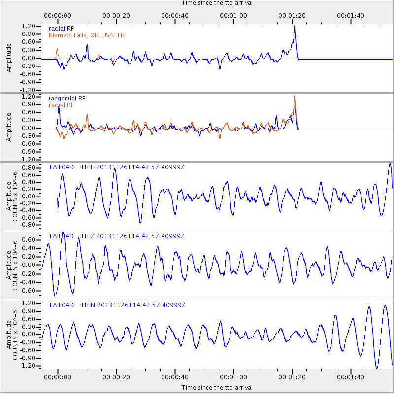
L04D Klamath Falls, OR, USA - Earthquake Result Viewer
*The percent match for this event was below the threshold and hence no stack was calculated.
| Earthquake location: |
New Britain Region, P.N.G. |
| Earthquake latitude/longitude: |
-5.8/150.8 |
| Earthquake time(UTC): |
2013/11/26 (330) 14:30:28 GMT |
| Earthquake Depth: |
61 km |
| Earthquake Magnitude: |
5.5 MWB, 5.4 MWC |
| Earthquake Catalog/Contributor: |
NEIC PDE/NEIC COMCAT |
|
| Network: |
TA USArray Transportable Network (new EarthScope stations) |
| Station: |
L04D Klamath Falls, OR, USA |
| Lat/Lon: |
42.22 N/122.30 W |
| Elevation: |
1437 m |
|
| Distance: |
91.6 deg |
| Az: |
47.907 deg |
| Baz: |
263.65 deg |
| Ray Param: |
$rayparam |
*The percent match for this event was below the threshold and hence was not used in the summary stack. |
|
| Radial Match: |
67.97269 % |
| Radial Bump: |
400 |
| Transverse Match: |
50.411304 % |
| Transverse Bump: |
399 |
| SOD ConfigId: |
626651 |
| Insert Time: |
2014-04-19 21:32:03.865 +0000 |
| GWidth: |
2.5 |
| Max Bumps: |
400 |
| Tol: |
0.001 |
|
Signal To Noise
| Channel | StoN | STA | LTA |
| TA:L04D: :HHZ:20131126T14:42:57.40999Z | 2.9131699 | 5.1287924E-7 | 1.760554E-7 |
| TA:L04D: :HHN:20131126T14:42:57.40999Z | 1.2405026 | 3.1235197E-7 | 2.517947E-7 |
| TA:L04D: :HHE:20131126T14:42:57.40999Z | 1.0191336 | 3.8002207E-7 | 3.728874E-7 |
| Arrivals |
| Ps | |
| PpPs | |
| PsPs/PpSs | |


