You are here: Home > Network List > CI - Caltech Regional Seismic Network Stations List
> Station CIA CIA, Avalon Catalina Island, CA, USA > Earthquake Result Viewer
CIA CIA, Avalon Catalina Island, CA, USA - Earthquake Result Viewer
| Earthquake location: |
Samoa Islands Region |
| Earthquake latitude/longitude: |
-16.6/-172.0 |
| Earthquake time(UTC): |
2006/09/28 (271) 06:22:09 GMT |
| Earthquake Depth: |
28 km |
| Earthquake Magnitude: |
6.5 MB, 6.6 MS, 6.9 MW, 6.7 MW |
| Earthquake Catalog/Contributor: |
WHDF/NEIC |
|
| Network: |
CI Caltech Regional Seismic Network |
| Station: |
CIA CIA, Avalon Catalina Island, CA, USA |
| Lat/Lon: |
33.40 N/118.41 W |
| Elevation: |
467 m |
|
| Distance: |
71.3 deg |
| Az: |
45.311 deg |
| Baz: |
234.579 deg |
| Ray Param: |
0.05436868 |
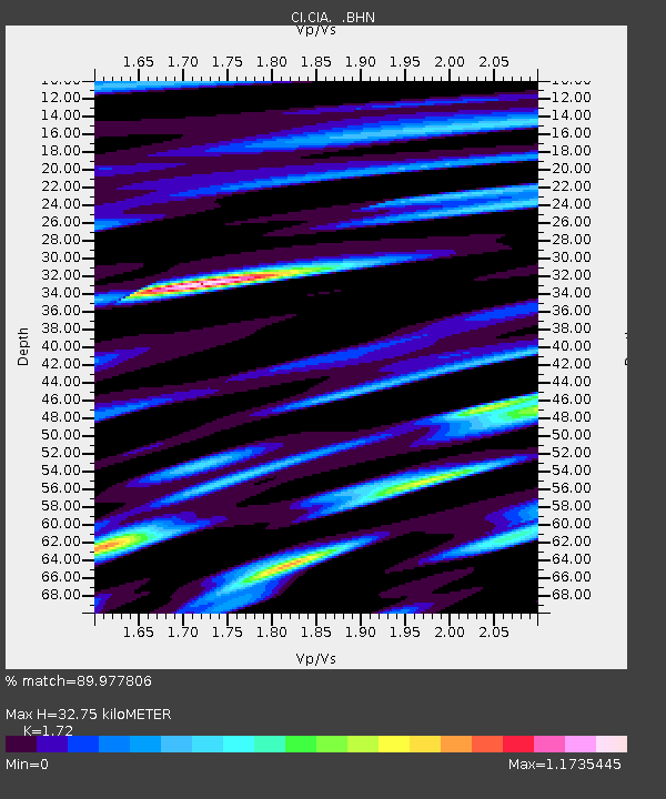
| Estimated Moho Depth: |
32.75 km |
| Estimated Crust Vp/Vs: |
1.72 |
| Assumed Crust Vp: |
6.048 km/s |
| Estimated Crust Vs: |
3.516 km/s |
| Estimated Crust Poisson's Ratio: |
0.24 |
|
| Radial Match: |
89.977806 % |
| Radial Bump: |
400 |
| Transverse Match: |
91.44885 % |
| Transverse Bump: |
314 |
| SOD ConfigId: |
2665 |
| Insert Time: |
2010-02-25 20:54:19.816 +0000 |
| GWidth: |
2.5 |
| Max Bumps: |
400 |
| Tol: |
0.001 |
|
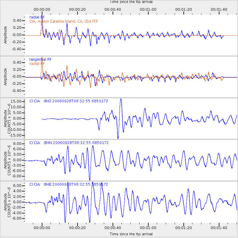
Signal To Noise
| Channel | StoN | STA | LTA |
| CI:CIA: :BHN:20060928T06:32:55.685017Z | 9.060728 | 1.0419415E-6 | 1.1499534E-7 |
| CI:CIA: :BHE:20060928T06:32:55.685017Z | 10.380189 | 1.2847582E-6 | 1.2377022E-7 |
| CI:CIA: :BHZ:20060928T06:32:55.685017Z | 15.745032 | 3.6716995E-6 | 2.3319733E-7 |
| Arrivals |
| Ps | 4.0 SECOND |
| PpPs | 14 SECOND |
| PsPs/PpSs | 18 SECOND |


