You are here: Home > Network List > US - United States National Seismic Network Stations List
> Station AMTX Amarillo, Texas, USA > Earthquake Result Viewer
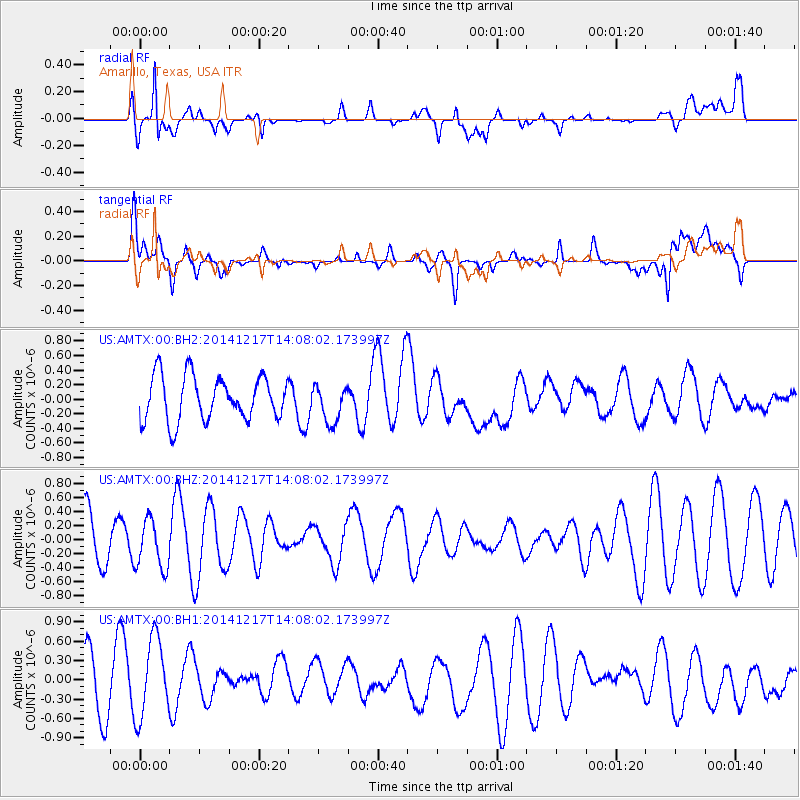
AMTX Amarillo, Texas, USA - Earthquake Result Viewer
*The percent match for this event was below the threshold and hence no stack was calculated.
| Earthquake location: |
Iceland |
| Earthquake latitude/longitude: |
64.6/-17.8 |
| Earthquake time(UTC): |
2014/12/17 (351) 13:58:50 GMT |
| Earthquake Depth: |
8.2 km |
| Earthquake Magnitude: |
5.3 MW, 5.1 mb, 5.3 Mww, 5.3 Mwc |
| Earthquake Catalog/Contributor: |
ISC/ISC |
|
| Network: |
US United States National Seismic Network |
| Station: |
AMTX Amarillo, Texas, USA |
| Lat/Lon: |
34.53 N/101.41 W |
| Elevation: |
1010 m |
|
| Distance: |
56.7 deg |
| Az: |
281.102 deg |
| Baz: |
30.85 deg |
| Ray Param: |
$rayparam |
*The percent match for this event was below the threshold and hence was not used in the summary stack. |
|
| Radial Match: |
64.22843 % |
| Radial Bump: |
400 |
| Transverse Match: |
47.842278 % |
| Transverse Bump: |
400 |
| SOD ConfigId: |
3390531 |
| Insert Time: |
2019-04-15 14:33:30.593 +0000 |
| GWidth: |
2.5 |
| Max Bumps: |
400 |
| Tol: |
0.001 |
|
Signal To Noise
| Channel | StoN | STA | LTA |
| US:AMTX:00:BHZ:20141217T14:08:02.173997Z | 1.0544266 | 3.4509486E-7 | 3.2728204E-7 |
| US:AMTX:00:BH1:20141217T14:08:02.173997Z | 1.3301986 | 6.278949E-7 | 4.7203096E-7 |
| US:AMTX:00:BH2:20141217T14:08:02.173997Z | 0.90620416 | 2.6657892E-7 | 2.9417092E-7 |
| Arrivals |
| Ps | |
| PpPs | |
| PsPs/PpSs | |


