You are here: Home > Network List > AK - Alaska Regional Network Stations List
> Station GAMB Gambell Broadband > Earthquake Result Viewer
GAMB Gambell Broadband - Earthquake Result Viewer
| Earthquake location: |
Banda Sea |
| Earthquake latitude/longitude: |
-7.0/128.4 |
| Earthquake time(UTC): |
2013/12/01 (335) 01:24:13 GMT |
| Earthquake Depth: |
9.9 km |
| Earthquake Magnitude: |
6.4 MWW, 6.4 MWB, 6.5 MWC |
| Earthquake Catalog/Contributor: |
NEIC PDE/NEIC COMCAT |
|
| Network: |
AK Alaska Regional Network |
| Station: |
GAMB Gambell Broadband |
| Lat/Lon: |
63.78 N/171.70 W |
| Elevation: |
10 m |
|
| Distance: |
83.6 deg |
| Az: |
22.76 deg |
| Baz: |
239.81 deg |
| Ray Param: |
0.046100676 |
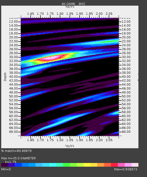
| Estimated Moho Depth: |
30.0 km |
| Estimated Crust Vp/Vs: |
1.75 |
| Assumed Crust Vp: |
6.24 km/s |
| Estimated Crust Vs: |
3.566 km/s |
| Estimated Crust Poisson's Ratio: |
0.26 |
|
| Radial Match: |
90.98978 % |
| Radial Bump: |
400 |
| Transverse Match: |
57.779156 % |
| Transverse Bump: |
400 |
| SOD ConfigId: |
626651 |
| Insert Time: |
2014-04-19 21:53:41.621 +0000 |
| GWidth: |
2.5 |
| Max Bumps: |
400 |
| Tol: |
0.001 |
|

Signal To Noise
| Channel | StoN | STA | LTA |
| AK:GAMB: :BHZ:20131201T01:36:10.248027Z | 9.914804 | 4.077995E-6 | 4.113036E-7 |
| AK:GAMB: :BHN:20131201T01:36:10.248027Z | 2.7192144 | 8.257539E-7 | 3.036737E-7 |
| AK:GAMB: :BHE:20131201T01:36:10.248027Z | 3.9172382 | 1.2655686E-6 | 3.2307676E-7 |
| Arrivals |
| Ps | 3.7 SECOND |
| PpPs | 13 SECOND |
| PsPs/PpSs | 17 SECOND |


