You are here: Home > Network List > AU - Australian Seismological Centre Stations List
> Station NIUE Niue Island, Niue > Earthquake Result Viewer
NIUE Niue Island, Niue - Earthquake Result Viewer
| Earthquake location: |
Banda Sea |
| Earthquake latitude/longitude: |
-7.0/128.4 |
| Earthquake time(UTC): |
2013/12/01 (335) 01:24:13 GMT |
| Earthquake Depth: |
9.9 km |
| Earthquake Magnitude: |
6.4 MWW, 6.4 MWB, 6.5 MWC |
| Earthquake Catalog/Contributor: |
NEIC PDE/NEIC COMCAT |
|
| Network: |
AU Australian Seismological Centre |
| Station: |
NIUE Niue Island, Niue |
| Lat/Lon: |
19.08 S/169.93 W |
| Elevation: |
109 m |
|
| Distance: |
61.0 deg |
| Az: |
107.839 deg |
| Baz: |
272.488 deg |
| Ray Param: |
0.06115293 |
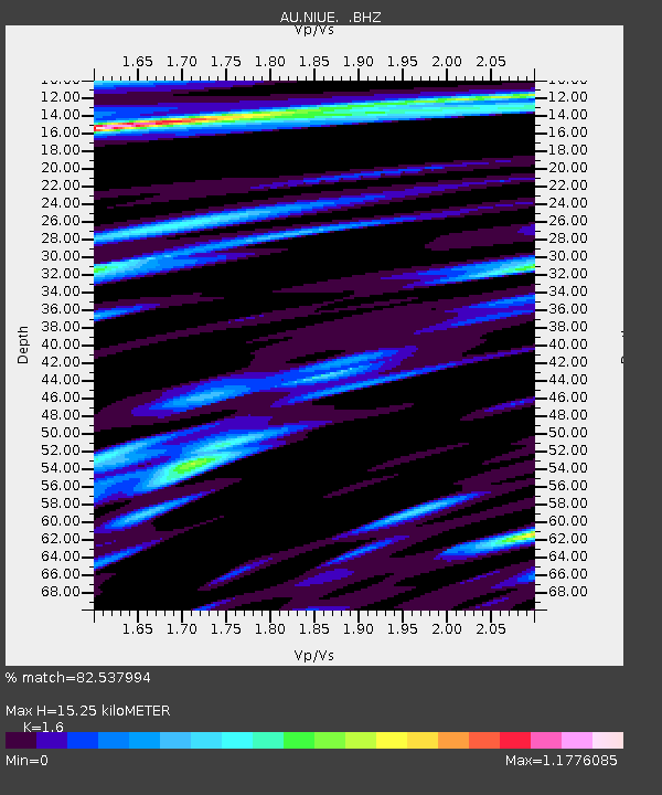
| Estimated Moho Depth: |
15.25 km |
| Estimated Crust Vp/Vs: |
1.60 |
| Assumed Crust Vp: |
4.24 km/s |
| Estimated Crust Vs: |
2.65 km/s |
| Estimated Crust Poisson's Ratio: |
0.18 |
|
| Radial Match: |
82.537994 % |
| Radial Bump: |
400 |
| Transverse Match: |
68.95705 % |
| Transverse Bump: |
400 |
| SOD ConfigId: |
626651 |
| Insert Time: |
2014-04-19 21:56:31.702 +0000 |
| GWidth: |
2.5 |
| Max Bumps: |
400 |
| Tol: |
0.001 |
|

Signal To Noise
| Channel | StoN | STA | LTA |
| AU:NIUE: :BHZ:20131201T01:33:55.993999Z | 4.4263215 | 6.1551837E-6 | 1.3905866E-6 |
| AU:NIUE: :BHN:20131201T01:33:55.993999Z | 1.4369683 | 2.7286158E-6 | 1.8988699E-6 |
| AU:NIUE: :BHE:20131201T01:33:55.993999Z | 1.7548817 | 5.3712715E-6 | 3.0607598E-6 |
| Arrivals |
| Ps | 2.2 SECOND |
| PpPs | 9.2 SECOND |
| PsPs/PpSs | 11 SECOND |


