You are here: Home > Network List > CB - China National Seismic Network Stations List
> Station DL2 Dalian,Liaoning Province > Earthquake Result Viewer
DL2 Dalian,Liaoning Province - Earthquake Result Viewer
| Earthquake location: |
Banda Sea |
| Earthquake latitude/longitude: |
-7.0/128.4 |
| Earthquake time(UTC): |
2013/12/01 (335) 01:24:13 GMT |
| Earthquake Depth: |
9.9 km |
| Earthquake Magnitude: |
6.4 MWW, 6.4 MWB, 6.5 MWC |
| Earthquake Catalog/Contributor: |
NEIC PDE/NEIC COMCAT |
|
| Network: |
CB China National Seismic Network |
| Station: |
DL2 Dalian,Liaoning Province |
| Lat/Lon: |
38.91 N/121.63 E |
| Elevation: |
65 m |
|
| Distance: |
46.1 deg |
| Az: |
352.69 deg |
| Baz: |
170.685 deg |
| Ray Param: |
0.070837386 |
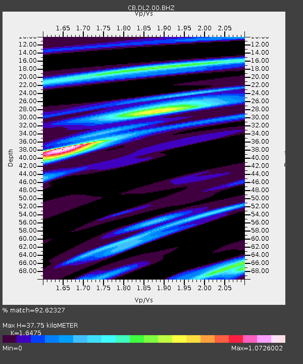
| Estimated Moho Depth: |
37.75 km |
| Estimated Crust Vp/Vs: |
1.65 |
| Assumed Crust Vp: |
6.134 km/s |
| Estimated Crust Vs: |
3.723 km/s |
| Estimated Crust Poisson's Ratio: |
0.21 |
|
| Radial Match: |
92.62327 % |
| Radial Bump: |
299 |
| Transverse Match: |
79.10242 % |
| Transverse Bump: |
400 |
| SOD ConfigId: |
626651 |
| Insert Time: |
2014-04-19 21:57:28.996 +0000 |
| GWidth: |
2.5 |
| Max Bumps: |
400 |
| Tol: |
0.001 |
|

Signal To Noise
| Channel | StoN | STA | LTA |
| CB:DL2:00:BHZ:20131201T01:32:06.990001Z | 9.1437235 | 3.13835E-6 | 3.432245E-7 |
| CB:DL2:00:BHN:20131201T01:32:06.990001Z | 6.6511445 | 1.6282241E-6 | 2.448036E-7 |
| CB:DL2:00:BHE:20131201T01:32:06.990001Z | 2.5822487 | 5.7707723E-7 | 2.2347857E-7 |
| Arrivals |
| Ps | 4.2 SECOND |
| PpPs | 15 SECOND |
| PsPs/PpSs | 20 SECOND |


