You are here: Home > Network List > CN - Canadian National Seismograph Network Stations List
> Station INK INUVIK, NT > Earthquake Result Viewer
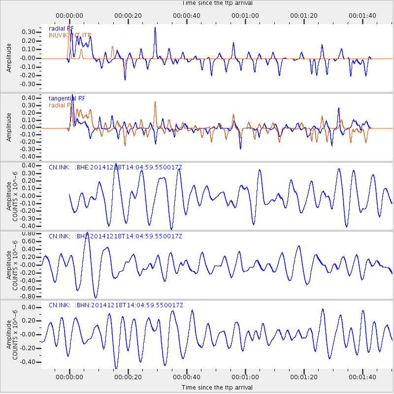
INK INUVIK, NT - Earthquake Result Viewer
*The percent match for this event was below the threshold and hence no stack was calculated.
| Earthquake location: |
Samoa Islands Region |
| Earthquake latitude/longitude: |
-16.0/-173.0 |
| Earthquake time(UTC): |
2014/12/18 (352) 13:52:35 GMT |
| Earthquake Depth: |
0.0 km |
| Earthquake Magnitude: |
5.0 MW, 4.4 mb, 4.6 mb1, 4.5 mb1mx, 4.5 mbtmp, 5.1 ML, 3.8 MS, 3.8 Ms1, 3.6 ms1mx |
| Earthquake Catalog/Contributor: |
ISC/ISC |
|
| Network: |
CN Canadian National Seismograph Network |
| Station: |
INK INUVIK, NT |
| Lat/Lon: |
68.31 N/133.53 W |
| Elevation: |
44 m |
|
| Distance: |
88.7 deg |
| Az: |
13.675 deg |
| Baz: |
217.706 deg |
| Ray Param: |
$rayparam |
*The percent match for this event was below the threshold and hence was not used in the summary stack. |
|
| Radial Match: |
52.27968 % |
| Radial Bump: |
400 |
| Transverse Match: |
60.23423 % |
| Transverse Bump: |
400 |
| SOD ConfigId: |
3390531 |
| Insert Time: |
2019-04-15 14:44:02.561 +0000 |
| GWidth: |
2.5 |
| Max Bumps: |
400 |
| Tol: |
0.001 |
|
Signal To Noise
| Channel | StoN | STA | LTA |
| CN:INK: :BHZ:20141218T14:04:59.550017Z | 2.343703 | 3.398935E-7 | 1.4502413E-7 |
| CN:INK: :BHN:20141218T14:04:59.550017Z | 0.98292893 | 1.9043578E-7 | 1.9374319E-7 |
| CN:INK: :BHE:20141218T14:04:59.550017Z | 1.2089618 | 2.3035543E-7 | 1.9053986E-7 |
| Arrivals |
| Ps | |
| PpPs | |
| PsPs/PpSs | |


