You are here: Home > Network List > G - GEOSCOPE Stations List
> Station INU Inuyama, Japan > Earthquake Result Viewer
INU Inuyama, Japan - Earthquake Result Viewer
| Earthquake location: |
Banda Sea |
| Earthquake latitude/longitude: |
-7.0/128.4 |
| Earthquake time(UTC): |
2013/12/01 (335) 01:24:13 GMT |
| Earthquake Depth: |
9.9 km |
| Earthquake Magnitude: |
6.4 MWW, 6.4 MWB, 6.5 MWC |
| Earthquake Catalog/Contributor: |
NEIC PDE/NEIC COMCAT |
|
| Network: |
G GEOSCOPE |
| Station: |
INU Inuyama, Japan |
| Lat/Lon: |
35.35 N/137.03 E |
| Elevation: |
132 m |
|
| Distance: |
42.9 deg |
| Az: |
10.399 deg |
| Baz: |
192.66 deg |
| Ray Param: |
0.072875924 |
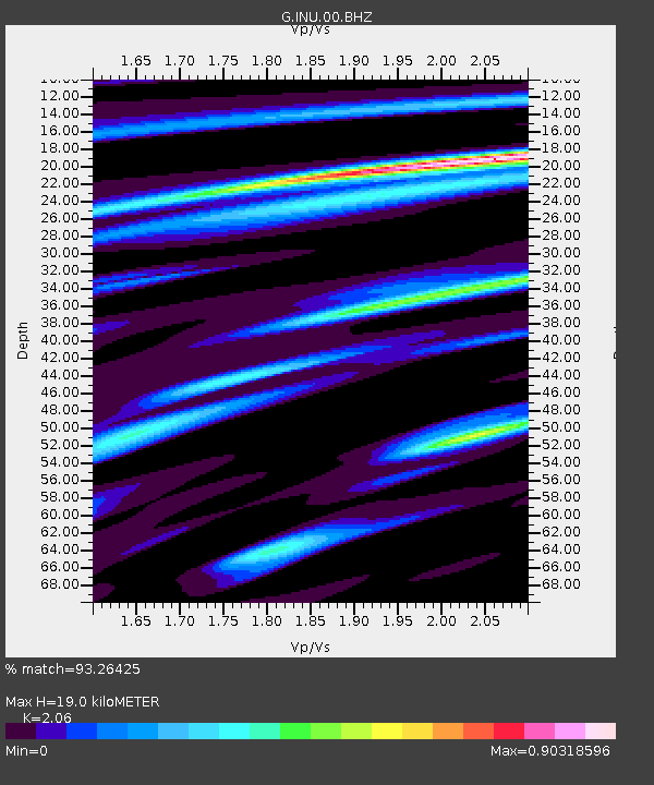
| Estimated Moho Depth: |
19.0 km |
| Estimated Crust Vp/Vs: |
2.06 |
| Assumed Crust Vp: |
6.461 km/s |
| Estimated Crust Vs: |
3.137 km/s |
| Estimated Crust Poisson's Ratio: |
0.35 |
|
| Radial Match: |
93.26425 % |
| Radial Bump: |
275 |
| Transverse Match: |
85.95697 % |
| Transverse Bump: |
400 |
| SOD ConfigId: |
626651 |
| Insert Time: |
2014-04-19 21:58:19.729 +0000 |
| GWidth: |
2.5 |
| Max Bumps: |
400 |
| Tol: |
0.001 |
|

Signal To Noise
| Channel | StoN | STA | LTA |
| G:INU:00:BHZ:20131201T01:31:41.510997Z | 15.810187 | 3.8789426E-6 | 2.4534452E-7 |
| G:INU:00:BHN:20131201T01:31:41.510997Z | 5.657547 | 1.916161E-6 | 3.3869114E-7 |
| G:INU:00:BHE:20131201T01:31:41.510997Z | 6.87557 | 1.0722433E-6 | 1.5594973E-7 |
| Arrivals |
| Ps | 3.3 SECOND |
| PpPs | 8.5 SECOND |
| PsPs/PpSs | 12 SECOND |


