You are here: Home > Network List > GE - GEOFON Stations List
> Station DAMY GEOFON Station Dhamar, Yemen > Earthquake Result Viewer
DAMY GEOFON Station Dhamar, Yemen - Earthquake Result Viewer
| Earthquake location: |
Banda Sea |
| Earthquake latitude/longitude: |
-7.0/128.4 |
| Earthquake time(UTC): |
2013/12/01 (335) 01:24:13 GMT |
| Earthquake Depth: |
9.9 km |
| Earthquake Magnitude: |
6.4 MWW, 6.4 MWB, 6.5 MWC |
| Earthquake Catalog/Contributor: |
NEIC PDE/NEIC COMCAT |
|
| Network: |
GE GEOFON |
| Station: |
DAMY GEOFON Station Dhamar, Yemen |
| Lat/Lon: |
14.57 N/44.39 E |
| Elevation: |
2488 m |
|
| Distance: |
86.0 deg |
| Az: |
285.138 deg |
| Baz: |
98.281 deg |
| Ray Param: |
0.0443844 |
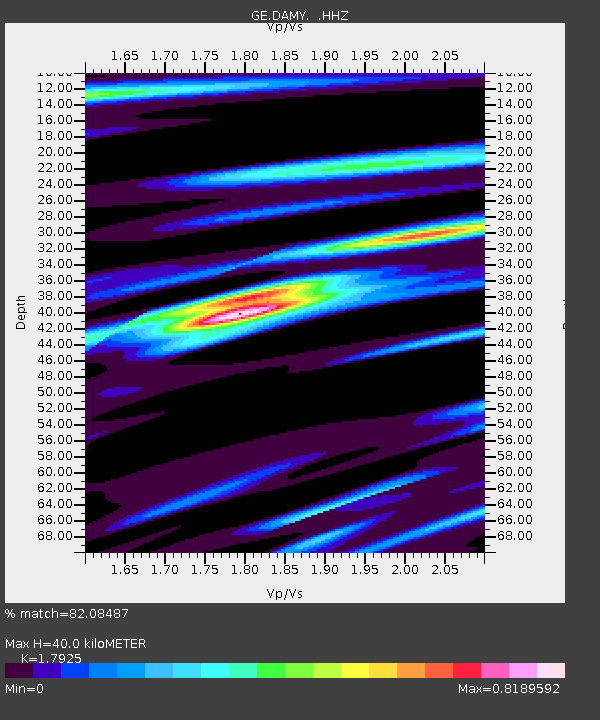
| Estimated Moho Depth: |
40.0 km |
| Estimated Crust Vp/Vs: |
1.79 |
| Assumed Crust Vp: |
6.65 km/s |
| Estimated Crust Vs: |
3.71 km/s |
| Estimated Crust Poisson's Ratio: |
0.27 |
|
| Radial Match: |
82.08487 % |
| Radial Bump: |
400 |
| Transverse Match: |
66.31857 % |
| Transverse Bump: |
400 |
| SOD ConfigId: |
626651 |
| Insert Time: |
2014-04-19 21:58:33.468 +0000 |
| GWidth: |
2.5 |
| Max Bumps: |
400 |
| Tol: |
0.001 |
|

Signal To Noise
| Channel | StoN | STA | LTA |
| GE:DAMY: :HHZ:20131201T01:36:22.337993Z | 14.31173 | 1.3681818E-6 | 9.559862E-8 |
| GE:DAMY: :HHN:20131201T01:36:22.337993Z | 0.8169136 | 3.577806E-7 | 4.3796626E-7 |
| GE:DAMY: :HHE:20131201T01:36:22.337993Z | 1.3025365 | 4.7270953E-7 | 3.6291465E-7 |
| Arrivals |
| Ps | 4.9 SECOND |
| PpPs | 16 SECOND |
| PsPs/PpSs | 21 SECOND |


