You are here: Home > Network List > IU - Global Seismograph Network (GSN - IRIS/USGS) Stations List
> Station MAJO Matsushiro, Japan > Earthquake Result Viewer
MAJO Matsushiro, Japan - Earthquake Result Viewer

| Earthquake location: |
Banda Sea |
| Earthquake latitude/longitude: |
-7.0/128.4 |
| Earthquake time(UTC): |
2013/12/01 (335) 01:24:13 GMT |
| Earthquake Depth: |
9.9 km |
| Earthquake Magnitude: |
6.4 MWW, 6.4 MWB, 6.5 MWC |
| Earthquake Catalog/Contributor: |
NEIC PDE/NEIC COMCAT |
|
| Network: |
IU Global Seismograph Network (GSN - IRIS/USGS) |
| Station: |
MAJO Matsushiro, Japan |
| Lat/Lon: |
36.55 N/138.20 E |
| Elevation: |
405 m |
|
| Distance: |
44.3 deg |
| Az: |
11.345 deg |
| Baz: |
194.032 deg |
| Ray Param: |
0.071994334 |
| Estimated Moho Depth: |
61.5 km |
| Estimated Crust Vp/Vs: |
1.80 |
| Assumed Crust Vp: |
6.461 km/s |
| Estimated Crust Vs: |
3.59 km/s |
| Estimated Crust Poisson's Ratio: |
0.28 |
|
| Radial Match: |
91.344894 % |
| Radial Bump: |
342 |
| Transverse Match: |
85.601295 % |
| Transverse Bump: |
400 |
| SOD ConfigId: |
626651 |
| Insert Time: |
2014-04-19 22:01:15.859 +0000 |
| GWidth: |
2.5 |
| Max Bumps: |
400 |
| Tol: |
0.001 |
|
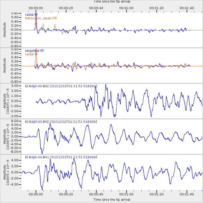
Signal To Noise
| Channel | StoN | STA | LTA |
| IU:MAJO:00:BHZ:20131201T01:31:52.618999Z | 24.1755 | 4.3528735E-6 | 1.8005309E-7 |
| IU:MAJO:00:BH1:20131201T01:31:52.618999Z | 11.935225 | 2.7232445E-6 | 2.281687E-7 |
| IU:MAJO:00:BH2:20131201T01:31:52.618999Z | 2.8778071 | 6.862878E-7 | 2.3847596E-7 |
| Arrivals |
| Ps | 8.1 SECOND |
| PpPs | 25 SECOND |
| PsPs/PpSs | 33 SECOND |


