You are here: Home > Network List > YT07 - POLENET Stations List
> Station PECA PECA > Earthquake Result Viewer
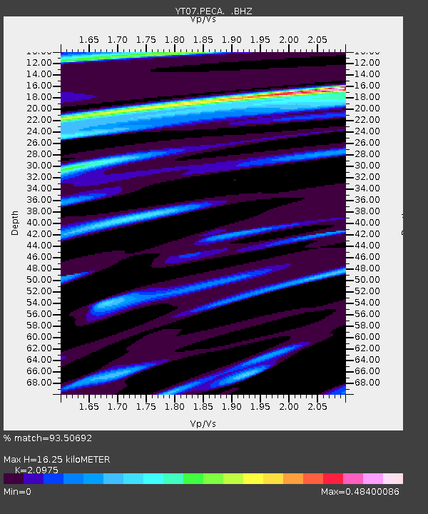
PECA PECA - Earthquake Result Viewer
| Earthquake location: |
Banda Sea |
| Earthquake latitude/longitude: |
-7.0/128.4 |
| Earthquake time(UTC): |
2013/12/01 (335) 01:24:13 GMT |
| Earthquake Depth: |
9.9 km |
| Earthquake Magnitude: |
6.4 MWW, 6.4 MWB, 6.5 MWC |
| Earthquake Catalog/Contributor: |
NEIC PDE/NEIC COMCAT |
|
| Network: |
YT POLENET |
| Station: |
PECA PECA |
| Lat/Lon: |
85.61 S/68.55 W |
| Elevation: |
1514 m |
|
| Distance: |
87.2 deg |
| Az: |
178.713 deg |
| Baz: |
196.822 deg |
| Ray Param: |
0.043460675 |
| Estimated Moho Depth: |
16.25 km |
| Estimated Crust Vp/Vs: |
2.10 |
| Assumed Crust Vp: |
6.39 km/s |
| Estimated Crust Vs: |
3.046 km/s |
| Estimated Crust Poisson's Ratio: |
0.35 |
|
| Radial Match: |
93.50692 % |
| Radial Bump: |
400 |
| Transverse Match: |
85.98917 % |
| Transverse Bump: |
400 |
| SOD ConfigId: |
626651 |
| Insert Time: |
2014-04-19 22:05:20.888 +0000 |
| GWidth: |
2.5 |
| Max Bumps: |
400 |
| Tol: |
0.001 |
|

Signal To Noise
| Channel | StoN | STA | LTA |
| YT:PECA: :BHZ:20131201T01:36:28.574993Z | 25.17063 | 3.783988E-6 | 1.5033346E-7 |
| YT:PECA: :BHN:20131201T01:36:28.574993Z | 8.4073925 | 8.0053036E-7 | 9.521744E-8 |
| YT:PECA: :BHE:20131201T01:36:28.574993Z | 2.3631864 | 2.4386986E-7 | 1.0319536E-7 |
| Arrivals |
| Ps | 2.8 SECOND |
| PpPs | 7.7 SECOND |
| PsPs/PpSs | 11 SECOND |


