You are here: Home > Network List > TA - USArray Transportable Network (new EarthScope stations) Stations List
> Station O48A Farmland, IN, USA > Earthquake Result Viewer
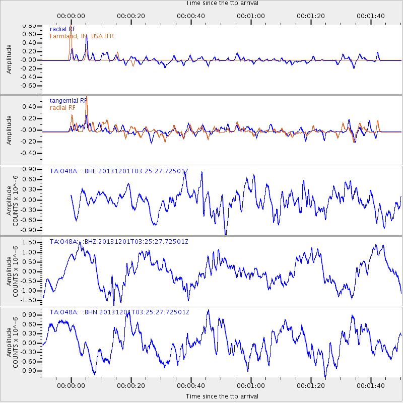
O48A Farmland, IN, USA - Earthquake Result Viewer
*The percent match for this event was below the threshold and hence no stack was calculated.
| Earthquake location: |
Off Coast Of Northern California |
| Earthquake latitude/longitude: |
41.7/-126.9 |
| Earthquake time(UTC): |
2013/12/01 (335) 03:19:38 GMT |
| Earthquake Depth: |
10 km |
| Earthquake Magnitude: |
5.5 MWW, 5.5 MW, 5.5 MW, 5.5 MWC, 5.5 MI, 5.5 MWR |
| Earthquake Catalog/Contributor: |
NEIC PDE/NEIC COMCAT |
|
| Network: |
TA USArray Transportable Network (new EarthScope stations) |
| Station: |
O48A Farmland, IN, USA |
| Lat/Lon: |
40.26 N/85.16 W |
| Elevation: |
300 m |
|
| Distance: |
31.3 deg |
| Az: |
78.488 deg |
| Baz: |
286.446 deg |
| Ray Param: |
$rayparam |
*The percent match for this event was below the threshold and hence was not used in the summary stack. |
|
| Radial Match: |
80.66193 % |
| Radial Bump: |
400 |
| Transverse Match: |
71.19813 % |
| Transverse Bump: |
400 |
| SOD ConfigId: |
626651 |
| Insert Time: |
2014-04-19 22:19:20.248 +0000 |
| GWidth: |
2.5 |
| Max Bumps: |
400 |
| Tol: |
0.001 |
|
Signal To Noise
| Channel | StoN | STA | LTA |
| TA:O48A: :BHZ:20131201T03:25:27.72501Z | 2.2068775 | 1.1285812E-6 | 5.113928E-7 |
| TA:O48A: :BHN:20131201T03:25:27.72501Z | 0.9487895 | 3.915533E-7 | 4.1268723E-7 |
| TA:O48A: :BHE:20131201T03:25:27.72501Z | 1.1735421 | 2.4159897E-7 | 2.0587156E-7 |
| Arrivals |
| Ps | |
| PpPs | |
| PsPs/PpSs | |


