You are here: Home > Network List > TA - USArray Transportable Network (new EarthScope stations) Stations List
> Station Q58A Fox Den Farm, The Plains, VA, USA > Earthquake Result Viewer
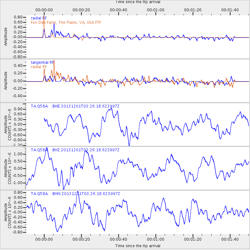
Q58A Fox Den Farm, The Plains, VA, USA - Earthquake Result Viewer
*The percent match for this event was below the threshold and hence no stack was calculated.
| Earthquake location: |
Off Coast Of Northern California |
| Earthquake latitude/longitude: |
41.7/-126.9 |
| Earthquake time(UTC): |
2013/12/01 (335) 03:19:38 GMT |
| Earthquake Depth: |
10 km |
| Earthquake Magnitude: |
5.5 MWW, 5.5 MW, 5.5 MW, 5.5 MWC, 5.5 MI, 5.5 MWR |
| Earthquake Catalog/Contributor: |
NEIC PDE/NEIC COMCAT |
|
| Network: |
TA USArray Transportable Network (new EarthScope stations) |
| Station: |
Q58A Fox Den Farm, The Plains, VA, USA |
| Lat/Lon: |
38.94 N/77.68 W |
| Elevation: |
182 m |
|
| Distance: |
37.2 deg |
| Az: |
77.464 deg |
| Baz: |
290.347 deg |
| Ray Param: |
$rayparam |
*The percent match for this event was below the threshold and hence was not used in the summary stack. |
|
| Radial Match: |
88.355255 % |
| Radial Bump: |
400 |
| Transverse Match: |
55.3522 % |
| Transverse Bump: |
400 |
| SOD ConfigId: |
626651 |
| Insert Time: |
2014-04-19 22:20:16.108 +0000 |
| GWidth: |
2.5 |
| Max Bumps: |
400 |
| Tol: |
0.001 |
|
Signal To Noise
| Channel | StoN | STA | LTA |
| TA:Q58A: :BHZ:20131201T03:26:18.623997Z | 1.8995758 | 1.001763E-6 | 5.2736146E-7 |
| TA:Q58A: :BHN:20131201T03:26:18.623997Z | 0.87103724 | 2.5233965E-7 | 2.8970018E-7 |
| TA:Q58A: :BHE:20131201T03:26:18.623997Z | 1.3731457 | 5.412559E-7 | 3.941722E-7 |
| Arrivals |
| Ps | |
| PpPs | |
| PsPs/PpSs | |


