You are here: Home > Network List > TA - USArray Transportable Network (new EarthScope stations) Stations List
> Station V50A Pikevile, TN, USA > Earthquake Result Viewer
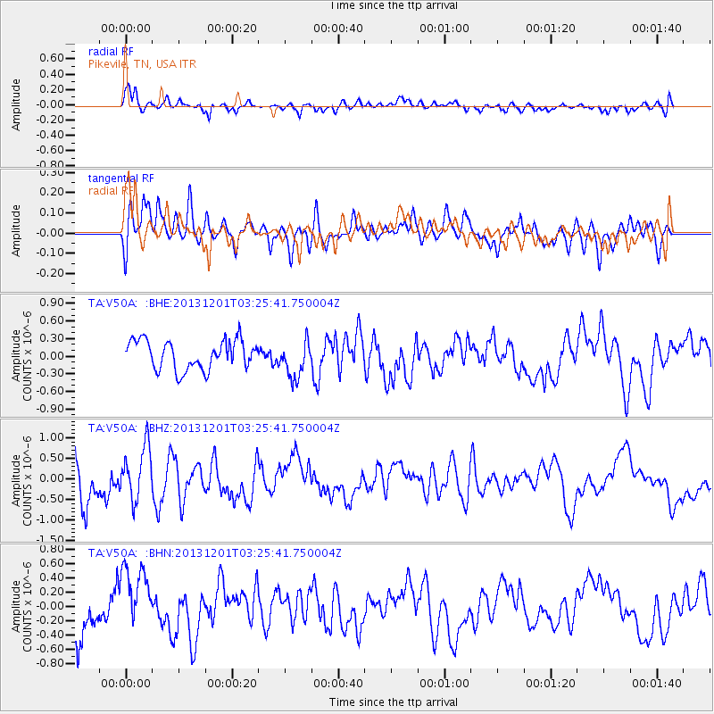
V50A Pikevile, TN, USA - Earthquake Result Viewer
*The percent match for this event was below the threshold and hence no stack was calculated.
| Earthquake location: |
Off Coast Of Northern California |
| Earthquake latitude/longitude: |
41.7/-126.9 |
| Earthquake time(UTC): |
2013/12/01 (335) 03:19:38 GMT |
| Earthquake Depth: |
10 km |
| Earthquake Magnitude: |
5.5 MWW, 5.5 MW, 5.5 MW, 5.5 MWC, 5.5 MI, 5.5 MWR |
| Earthquake Catalog/Contributor: |
NEIC PDE/NEIC COMCAT |
|
| Network: |
TA USArray Transportable Network (new EarthScope stations) |
| Station: |
V50A Pikevile, TN, USA |
| Lat/Lon: |
35.67 N/85.10 W |
| Elevation: |
287 m |
|
| Distance: |
32.9 deg |
| Az: |
86.563 deg |
| Baz: |
293.322 deg |
| Ray Param: |
$rayparam |
*The percent match for this event was below the threshold and hence was not used in the summary stack. |
|
| Radial Match: |
58.07403 % |
| Radial Bump: |
400 |
| Transverse Match: |
48.107914 % |
| Transverse Bump: |
400 |
| SOD ConfigId: |
626651 |
| Insert Time: |
2014-04-19 22:21:28.992 +0000 |
| GWidth: |
2.5 |
| Max Bumps: |
400 |
| Tol: |
0.001 |
|
Signal To Noise
| Channel | StoN | STA | LTA |
| TA:V50A: :BHZ:20131201T03:25:41.750004Z | 1.2705137 | 6.5549995E-7 | 5.1593304E-7 |
| TA:V50A: :BHN:20131201T03:25:41.750004Z | 1.5206851 | 5.0191954E-7 | 3.3006145E-7 |
| TA:V50A: :BHE:20131201T03:25:41.750004Z | 1.2945195 | 3.1815603E-7 | 2.457715E-7 |
| Arrivals |
| Ps | |
| PpPs | |
| PsPs/PpSs | |


