You are here: Home > Network List > US - United States National Seismic Network Stations List
> Station ERPA Erie, Pennsylvania, USA > Earthquake Result Viewer
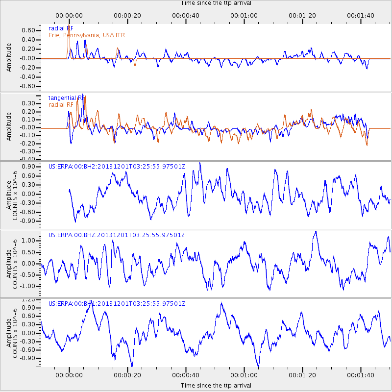
ERPA Erie, Pennsylvania, USA - Earthquake Result Viewer
*The percent match for this event was below the threshold and hence no stack was calculated.
| Earthquake location: |
Off Coast Of Northern California |
| Earthquake latitude/longitude: |
41.7/-126.9 |
| Earthquake time(UTC): |
2013/12/01 (335) 03:19:38 GMT |
| Earthquake Depth: |
10 km |
| Earthquake Magnitude: |
5.5 MWW, 5.5 MW, 5.5 MW, 5.5 MWC, 5.5 MI, 5.5 MWR |
| Earthquake Catalog/Contributor: |
NEIC PDE/NEIC COMCAT |
|
| Network: |
US United States National Seismic Network |
| Station: |
ERPA Erie, Pennsylvania, USA |
| Lat/Lon: |
42.12 N/79.99 W |
| Elevation: |
306 m |
|
| Distance: |
34.6 deg |
| Az: |
73.235 deg |
| Baz: |
285.425 deg |
| Ray Param: |
$rayparam |
*The percent match for this event was below the threshold and hence was not used in the summary stack. |
|
| Radial Match: |
76.561134 % |
| Radial Bump: |
400 |
| Transverse Match: |
61.0296 % |
| Transverse Bump: |
400 |
| SOD ConfigId: |
626651 |
| Insert Time: |
2014-04-19 22:22:50.352 +0000 |
| GWidth: |
2.5 |
| Max Bumps: |
400 |
| Tol: |
0.001 |
|
Signal To Noise
| Channel | StoN | STA | LTA |
| US:ERPA:00:BHZ:20131201T03:25:55.97501Z | 1.257326 | 4.5565733E-7 | 3.624019E-7 |
| US:ERPA:00:BH1:20131201T03:25:55.97501Z | 1.0379987 | 1.9011425E-7 | 1.8315461E-7 |
| US:ERPA:00:BH2:20131201T03:25:55.97501Z | 0.805474 | 3.5284336E-7 | 4.3805682E-7 |
| Arrivals |
| Ps | |
| PpPs | |
| PsPs/PpSs | |


