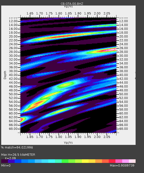
GTA Gaotai,Gansu Province - Earthquake Result Viewer

Earthquake location: Northern Sumatra, Indonesia
Earthquake latitude/longitude: 2.0/96.8
Earthquake time(UTC): 2013/12/01 (335) 06:29:57 GMT
Earthquake Depth: 20 km
Earthquake Magnitude: 6.0 MWW, 5.9 MWB, 5.9 MWW, 6.1 MWC
Earthquake Catalog/Contributor: NEIC PDE/NEIC COMCAT
Network: CB China National Seismic Network
Station: GTA Gaotai,Gansu Province
Lat/Lon: 39.40 N/99.82 E
Elevation: 1345 m
Distance: 37.3 deg
Az: 3.827 deg
Baz: 184.938 deg
Ray Param: 0.07619719
Estimated Moho Depth: 26.5 km
Estimated Crust Vp/Vs: 2.09
Assumed Crust Vp: 6.491 km/s
Estimated Crust Vs: 3.106 km/s
Estimated Crust Poisson's Ratio: 0.35
Radial Match: 94.021996 %
Radial Bump: 353
Transverse Match: 78.78867 %
Transverse Bump: 400
SOD ConfigId: 626651
Insert Time: 2014-04-19 22:25:57.362 +0000
GWidth: 2.5
Max Bumps: 400
Tol: 0.001

Signal To Noise

ChannelStoNSTALTA
CB:GTA:00:BHZ:20131201T06:36:37.56001Z22.3815526.396361E-72.8578718E-8
CB:GTA:00:BHN:20131201T06:36:37.56001Z11.4666173.3481163E-72.9198818E-8
CB:GTA:00:BHE:20131201T06:36:37.56001Z3.4896626.969195E-81.9970972E-8
Arrivals
Ps4.7 SECOND
PpPs12 SECOND
PsPs/PpSs17 SECOND