You are here: Home > Network List > TJ - Tajikistan National Seismic Network Stations List
> Station GARM Garm, Tajikistan > Earthquake Result Viewer
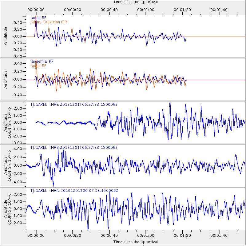
GARM Garm, Tajikistan - Earthquake Result Viewer
*The percent match for this event was below the threshold and hence no stack was calculated.
| Earthquake location: |
Northern Sumatra, Indonesia |
| Earthquake latitude/longitude: |
2.0/96.8 |
| Earthquake time(UTC): |
2013/12/01 (335) 06:29:57 GMT |
| Earthquake Depth: |
20 km |
| Earthquake Magnitude: |
6.0 MWW, 5.9 MWB, 5.9 MWW, 6.1 MWC |
| Earthquake Catalog/Contributor: |
NEIC PDE/NEIC COMCAT |
|
| Network: |
TJ Tajikistan National Seismic Network |
| Station: |
GARM Garm, Tajikistan |
| Lat/Lon: |
39.00 N/70.32 E |
| Elevation: |
1305 m |
|
| Distance: |
44.0 deg |
| Az: |
329.969 deg |
| Baz: |
140.069 deg |
| Ray Param: |
$rayparam |
*The percent match for this event was below the threshold and hence was not used in the summary stack. |
|
| Radial Match: |
71.02917 % |
| Radial Bump: |
386 |
| Transverse Match: |
66.90789 % |
| Transverse Bump: |
386 |
| SOD ConfigId: |
626651 |
| Insert Time: |
2014-04-19 22:32:45.632 +0000 |
| GWidth: |
2.5 |
| Max Bumps: |
400 |
| Tol: |
0.001 |
|
Signal To Noise
| Channel | StoN | STA | LTA |
| TJ:GARM: :HHZ:20131201T06:37:33.150006Z | 5.5743604 | 1.3353446E-6 | 2.3955118E-7 |
| TJ:GARM: :HHN:20131201T06:37:33.150006Z | 2.5740633 | 6.343473E-7 | 2.464381E-7 |
| TJ:GARM: :HHE:20131201T06:37:33.150006Z | 3.6361797 | 4.809155E-7 | 1.3225845E-7 |
| Arrivals |
| Ps | |
| PpPs | |
| PsPs/PpSs | |


