You are here: Home > Network List > TA - USArray Transportable Network (new EarthScope stations) Stations List
> Station M04C Macdoel, CA, USA > Earthquake Result Viewer
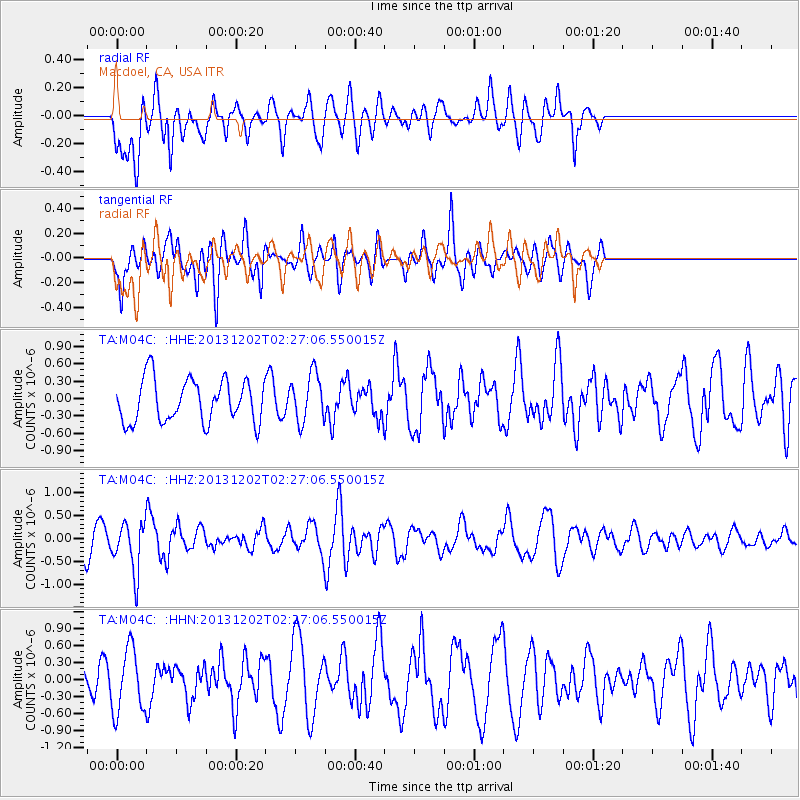
M04C Macdoel, CA, USA - Earthquake Result Viewer
*The percent match for this event was below the threshold and hence no stack was calculated.
| Earthquake location: |
Southeast Of Loyalty Islands |
| Earthquake latitude/longitude: |
-21.3/170.3 |
| Earthquake time(UTC): |
2013/12/02 (336) 02:14:56 GMT |
| Earthquake Depth: |
110 km |
| Earthquake Magnitude: |
5.6 MWW, 5.7 MWC, 5.7 MWB |
| Earthquake Catalog/Contributor: |
NEIC PDE/NEIC COMCAT |
|
| Network: |
TA USArray Transportable Network (new EarthScope stations) |
| Station: |
M04C Macdoel, CA, USA |
| Lat/Lon: |
41.78 N/121.84 W |
| Elevation: |
1391 m |
|
| Distance: |
88.7 deg |
| Az: |
43.858 deg |
| Baz: |
239.768 deg |
| Ray Param: |
$rayparam |
*The percent match for this event was below the threshold and hence was not used in the summary stack. |
|
| Radial Match: |
53.851757 % |
| Radial Bump: |
400 |
| Transverse Match: |
45.350075 % |
| Transverse Bump: |
388 |
| SOD ConfigId: |
626651 |
| Insert Time: |
2014-04-19 22:45:03.020 +0000 |
| GWidth: |
2.5 |
| Max Bumps: |
400 |
| Tol: |
0.001 |
|
Signal To Noise
| Channel | StoN | STA | LTA |
| TA:M04C: :HHZ:20131202T02:27:06.550015Z | 2.0143898 | 5.3440294E-7 | 2.6529273E-7 |
| TA:M04C: :HHN:20131202T02:27:06.550015Z | 1.5059764 | 5.617889E-7 | 3.7303963E-7 |
| TA:M04C: :HHE:20131202T02:27:06.550015Z | 1.1283056 | 4.13501E-7 | 3.664796E-7 |
| Arrivals |
| Ps | |
| PpPs | |
| PsPs/PpSs | |


