You are here: Home > Network List > TA - USArray Transportable Network (new EarthScope stations) Stations List
> Station N02D Trinity Center, CA, USA > Earthquake Result Viewer
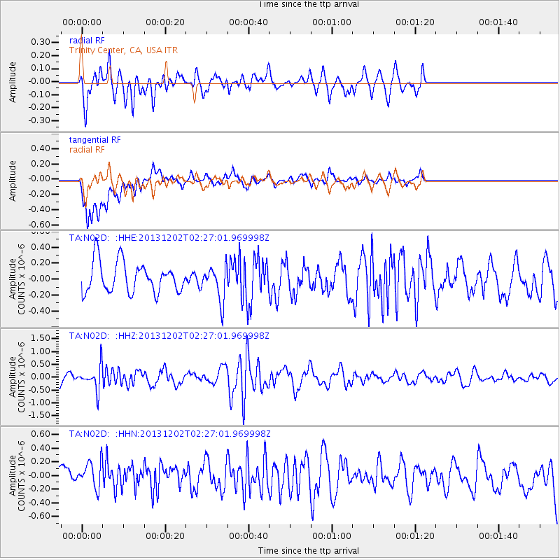
N02D Trinity Center, CA, USA - Earthquake Result Viewer
*The percent match for this event was below the threshold and hence no stack was calculated.
| Earthquake location: |
Southeast Of Loyalty Islands |
| Earthquake latitude/longitude: |
-21.3/170.3 |
| Earthquake time(UTC): |
2013/12/02 (336) 02:14:56 GMT |
| Earthquake Depth: |
110 km |
| Earthquake Magnitude: |
5.6 MWW, 5.7 MWC, 5.7 MWB |
| Earthquake Catalog/Contributor: |
NEIC PDE/NEIC COMCAT |
|
| Network: |
TA USArray Transportable Network (new EarthScope stations) |
| Station: |
N02D Trinity Center, CA, USA |
| Lat/Lon: |
40.97 N/122.71 W |
| Elevation: |
937 m |
|
| Distance: |
87.7 deg |
| Az: |
44.223 deg |
| Baz: |
239.209 deg |
| Ray Param: |
$rayparam |
*The percent match for this event was below the threshold and hence was not used in the summary stack. |
|
| Radial Match: |
63.445927 % |
| Radial Bump: |
400 |
| Transverse Match: |
51.786358 % |
| Transverse Bump: |
400 |
| SOD ConfigId: |
626651 |
| Insert Time: |
2014-04-19 22:45:07.242 +0000 |
| GWidth: |
2.5 |
| Max Bumps: |
400 |
| Tol: |
0.001 |
|
Signal To Noise
| Channel | StoN | STA | LTA |
| TA:N02D: :HHZ:20131202T02:27:01.969998Z | 2.0830343 | 4.672785E-7 | 2.243259E-7 |
| TA:N02D: :HHN:20131202T02:27:01.969998Z | 1.3313199 | 2.5612923E-7 | 1.9238745E-7 |
| TA:N02D: :HHE:20131202T02:27:01.969998Z | 1.1693991 | 2.2408427E-7 | 1.9162343E-7 |
| Arrivals |
| Ps | |
| PpPs | |
| PsPs/PpSs | |


