You are here: Home > Network List > CI - Caltech Regional Seismic Network Stations List
> Station CIA CIA, Avalon Catalina Island, CA, USA > Earthquake Result Viewer
CIA CIA, Avalon Catalina Island, CA, USA - Earthquake Result Viewer
| Earthquake location: |
Near Coast Of Northern Chile |
| Earthquake latitude/longitude: |
-27.2/-71.2 |
| Earthquake time(UTC): |
2006/04/30 (120) 21:32:55 GMT |
| Earthquake Depth: |
35 km |
| Earthquake Magnitude: |
5.6 MB, 5.9 MW, 5.4 ML |
| Earthquake Catalog/Contributor: |
WHDF/NEIC |
|
| Network: |
CI Caltech Regional Seismic Network |
| Station: |
CIA CIA, Avalon Catalina Island, CA, USA |
| Lat/Lon: |
33.40 N/118.41 W |
| Elevation: |
467 m |
|
| Distance: |
75.1 deg |
| Az: |
320.576 deg |
| Baz: |
137.467 deg |
| Ray Param: |
0.051830605 |
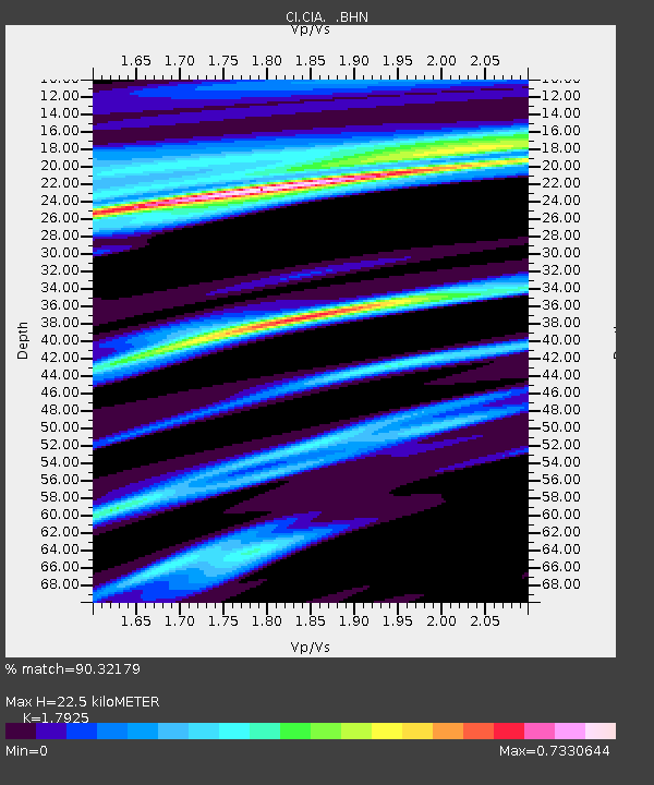
| Estimated Moho Depth: |
22.5 km |
| Estimated Crust Vp/Vs: |
1.79 |
| Assumed Crust Vp: |
6.048 km/s |
| Estimated Crust Vs: |
3.374 km/s |
| Estimated Crust Poisson's Ratio: |
0.27 |
|
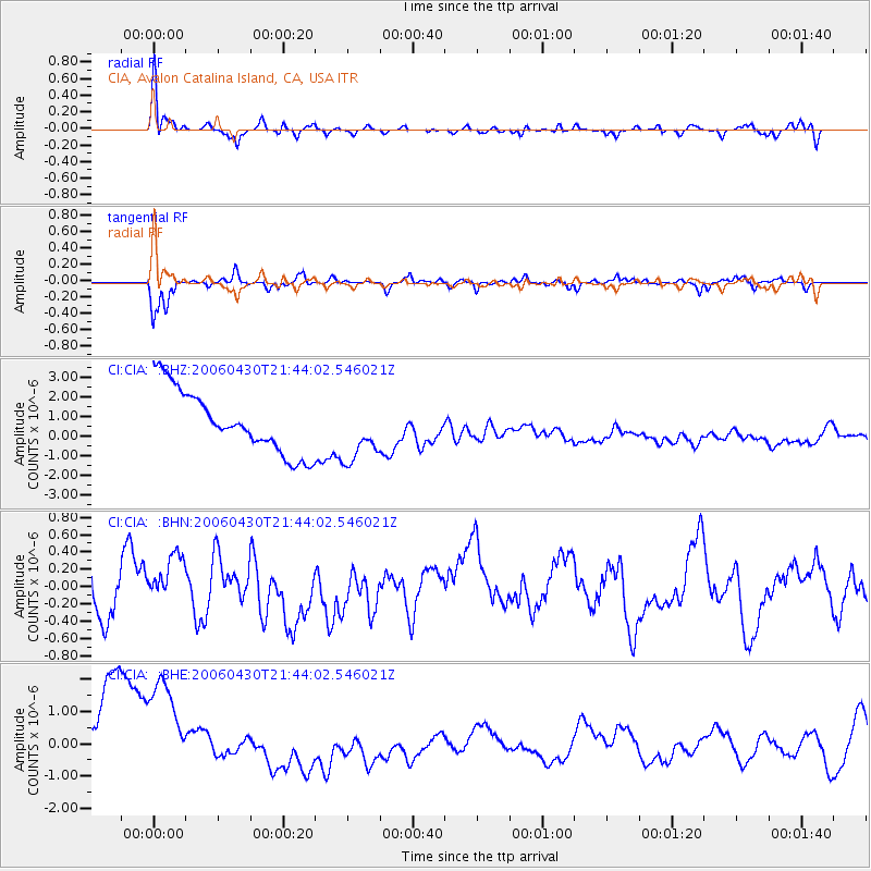
| Radial Match: |
90.32179 % |
| Radial Bump: |
400 |
| Transverse Match: |
91.28929 % |
| Transverse Bump: |
309 |
| SOD ConfigId: |
2669 |
| Insert Time: |
2010-02-25 20:54:30.444 +0000 |
| GWidth: |
2.5 |
| Max Bumps: |
400 |
| Tol: |
0.001 |
|
Signal To Noise
| Channel | StoN | STA | LTA |
| CI:CIA: :BHN:20060430T21:44:02.546021Z | 1.1378975 | 3.049083E-7 | 2.6795763E-7 |
| CI:CIA: :BHE:20060430T21:44:02.546021Z | 1.1471387 | 2.4956018E-6 | 2.1755013E-6 |
| CI:CIA: :BHZ:20060430T21:44:02.546021Z | 0.97264326 | 1.543605E-6 | 1.5870206E-6 |
| Arrivals |
| Ps | 3.0 SECOND |
| PpPs | 10 SECOND |
| PsPs/PpSs | 13 SECOND |


