You are here: Home > Network List > UU - University of Utah Regional Network Stations List
> Station CCUT Cedar City, UT, USA > Earthquake Result Viewer
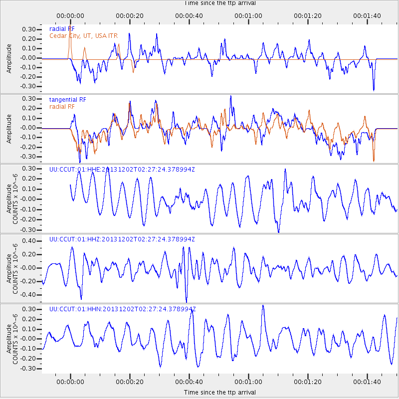
CCUT Cedar City, UT, USA - Earthquake Result Viewer
*The percent match for this event was below the threshold and hence no stack was calculated.
| Earthquake location: |
Southeast Of Loyalty Islands |
| Earthquake latitude/longitude: |
-21.3/170.3 |
| Earthquake time(UTC): |
2013/12/02 (336) 02:14:56 GMT |
| Earthquake Depth: |
110 km |
| Earthquake Magnitude: |
5.6 MWW, 5.7 MWC, 5.7 MWB |
| Earthquake Catalog/Contributor: |
NEIC PDE/NEIC COMCAT |
|
| Network: |
UU University of Utah Regional Network |
| Station: |
CCUT Cedar City, UT, USA |
| Lat/Lon: |
37.55 N/113.36 W |
| Elevation: |
2127 m |
|
| Distance: |
92.5 deg |
| Az: |
50.623 deg |
| Baz: |
245.098 deg |
| Ray Param: |
$rayparam |
*The percent match for this event was below the threshold and hence was not used in the summary stack. |
|
| Radial Match: |
63.95477 % |
| Radial Bump: |
400 |
| Transverse Match: |
63.64648 % |
| Transverse Bump: |
400 |
| SOD ConfigId: |
626651 |
| Insert Time: |
2014-04-19 22:46:18.450 +0000 |
| GWidth: |
2.5 |
| Max Bumps: |
400 |
| Tol: |
0.001 |
|
Signal To Noise
| Channel | StoN | STA | LTA |
| UU:CCUT:01:HHZ:20131202T02:27:24.378994Z | 1.7231652 | 2.3311716E-7 | 1.3528428E-7 |
| UU:CCUT:01:HHN:20131202T02:27:24.378994Z | 1.1533179 | 9.186401E-8 | 7.965194E-8 |
| UU:CCUT:01:HHE:20131202T02:27:24.378994Z | 0.8281525 | 1.16722084E-7 | 1.4094275E-7 |
| Arrivals |
| Ps | |
| PpPs | |
| PsPs/PpSs | |


