You are here: Home > Network List > II - Global Seismograph Network (GSN - IRIS/IDA) Stations List
> Station WRAB Tennant Creek, NT, Australia > Earthquake Result Viewer
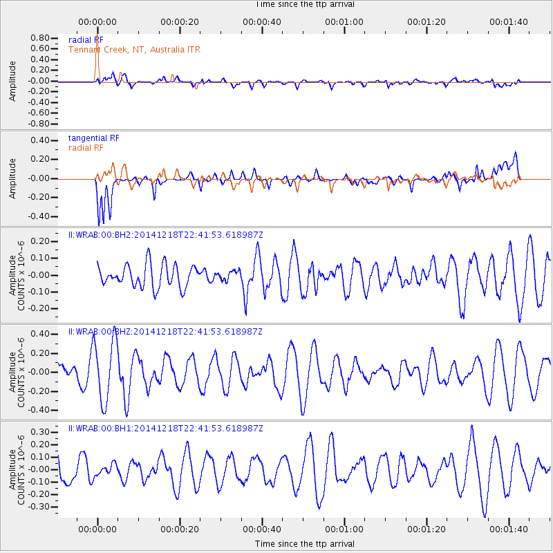
WRAB Tennant Creek, NT, Australia - Earthquake Result Viewer
*The percent match for this event was below the threshold and hence no stack was calculated.
| Earthquake location: |
Vanuatu Islands |
| Earthquake latitude/longitude: |
-15.0/167.0 |
| Earthquake time(UTC): |
2014/12/18 (352) 22:36:05 GMT |
| Earthquake Depth: |
36 km |
| Earthquake Magnitude: |
5.0 MW, 4.9 mb |
| Earthquake Catalog/Contributor: |
ISC/ISC |
|
| Network: |
II Global Seismograph Network (GSN - IRIS/IDA) |
| Station: |
WRAB Tennant Creek, NT, Australia |
| Lat/Lon: |
19.93 S/134.36 E |
| Elevation: |
366 m |
|
| Distance: |
31.5 deg |
| Az: |
256.331 deg |
| Baz: |
86.333 deg |
| Ray Param: |
$rayparam |
*The percent match for this event was below the threshold and hence was not used in the summary stack. |
|
| Radial Match: |
61.587658 % |
| Radial Bump: |
400 |
| Transverse Match: |
69.71748 % |
| Transverse Bump: |
400 |
| SOD ConfigId: |
3390531 |
| Insert Time: |
2019-04-15 15:05:33.066 +0000 |
| GWidth: |
2.5 |
| Max Bumps: |
400 |
| Tol: |
0.001 |
|
Signal To Noise
| Channel | StoN | STA | LTA |
| II:WRAB:00:BHZ:20141218T22:41:53.618987Z | 2.554078 | 3.2731378E-7 | 1.2815339E-7 |
| II:WRAB:00:BH1:20141218T22:41:53.618987Z | 0.32854223 | 4.4143054E-8 | 1.3436036E-7 |
| II:WRAB:00:BH2:20141218T22:41:53.618987Z | 0.42242026 | 2.794725E-8 | 6.615983E-8 |
| Arrivals |
| Ps | |
| PpPs | |
| PsPs/PpSs | |


