You are here: Home > Network List > AZ - ANZA Regional Network Stations List
> Station LVA2 AZ.LVA2 > Earthquake Result Viewer
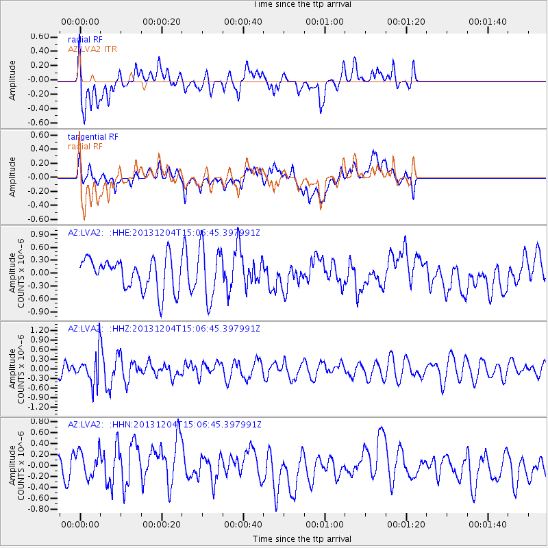
LVA2 AZ.LVA2 - Earthquake Result Viewer
*The percent match for this event was below the threshold and hence no stack was calculated.
| Earthquake location: |
South Of Fiji Islands |
| Earthquake latitude/longitude: |
-25.4/178.3 |
| Earthquake time(UTC): |
2013/12/04 (338) 14:55:40 GMT |
| Earthquake Depth: |
574 km |
| Earthquake Magnitude: |
5.7 MWW, 5.8 MWB, 5.8 MWC |
| Earthquake Catalog/Contributor: |
NEIC PDE/NEIC COMCAT |
|
| Network: |
AZ ANZA Regional Network |
| Station: |
LVA2 AZ.LVA2 |
| Lat/Lon: |
33.35 N/116.56 W |
| Elevation: |
1435 m |
|
| Distance: |
85.2 deg |
| Az: |
49.676 deg |
| Baz: |
235.439 deg |
| Ray Param: |
$rayparam |
*The percent match for this event was below the threshold and hence was not used in the summary stack. |
|
| Radial Match: |
54.62344 % |
| Radial Bump: |
400 |
| Transverse Match: |
36.532505 % |
| Transverse Bump: |
400 |
| SOD ConfigId: |
626651 |
| Insert Time: |
2014-04-19 23:10:50.662 +0000 |
| GWidth: |
2.5 |
| Max Bumps: |
400 |
| Tol: |
0.001 |
|
Signal To Noise
| Channel | StoN | STA | LTA |
| AZ:LVA2: :HHZ:20131204T15:06:45.397991Z | 2.1374362 | 4.5169625E-7 | 2.113262E-7 |
| AZ:LVA2: :HHN:20131204T15:06:45.397991Z | 1.2610242 | 2.9315245E-7 | 2.324717E-7 |
| AZ:LVA2: :HHE:20131204T15:06:45.397991Z | 1.7385014 | 6.3600385E-7 | 3.6583452E-7 |
| Arrivals |
| Ps | |
| PpPs | |
| PsPs/PpSs | |


