You are here: Home > Network List > TA - USArray Transportable Network (new EarthScope stations) Stations List
> Station H04D Lebanon, OR, USA > Earthquake Result Viewer
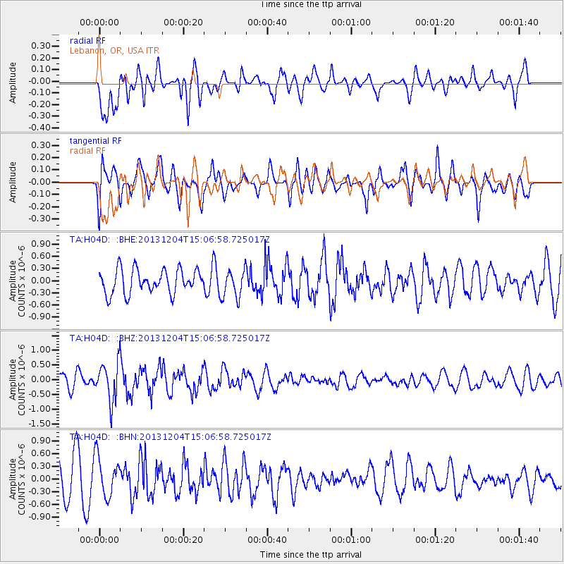
H04D Lebanon, OR, USA - Earthquake Result Viewer
*The percent match for this event was below the threshold and hence no stack was calculated.
| Earthquake location: |
South Of Fiji Islands |
| Earthquake latitude/longitude: |
-25.4/178.3 |
| Earthquake time(UTC): |
2013/12/04 (338) 14:55:40 GMT |
| Earthquake Depth: |
574 km |
| Earthquake Magnitude: |
5.7 MWW, 5.8 MWB, 5.8 MWC |
| Earthquake Catalog/Contributor: |
NEIC PDE/NEIC COMCAT |
|
| Network: |
TA USArray Transportable Network (new EarthScope stations) |
| Station: |
H04D Lebanon, OR, USA |
| Lat/Lon: |
44.52 N/122.74 W |
| Elevation: |
284 m |
|
| Distance: |
88.0 deg |
| Az: |
37.848 deg |
| Baz: |
230.85 deg |
| Ray Param: |
$rayparam |
*The percent match for this event was below the threshold and hence was not used in the summary stack. |
|
| Radial Match: |
54.27486 % |
| Radial Bump: |
400 |
| Transverse Match: |
55.712395 % |
| Transverse Bump: |
400 |
| SOD ConfigId: |
626651 |
| Insert Time: |
2014-04-19 23:19:39.116 +0000 |
| GWidth: |
2.5 |
| Max Bumps: |
400 |
| Tol: |
0.001 |
|
Signal To Noise
| Channel | StoN | STA | LTA |
| TA:H04D: :BHZ:20131204T15:06:58.725017Z | 2.1978657 | 6.684429E-7 | 3.0413273E-7 |
| TA:H04D: :BHN:20131204T15:06:58.725017Z | 1.1743281 | 4.6100777E-7 | 3.9257154E-7 |
| TA:H04D: :BHE:20131204T15:06:58.725017Z | 1.1775264 | 3.4670185E-7 | 2.9443237E-7 |
| Arrivals |
| Ps | |
| PpPs | |
| PsPs/PpSs | |


