You are here: Home > Network List > TA - USArray Transportable Network (new EarthScope stations) Stations List
> Station J01E Myrtle Point, OR, USA > Earthquake Result Viewer
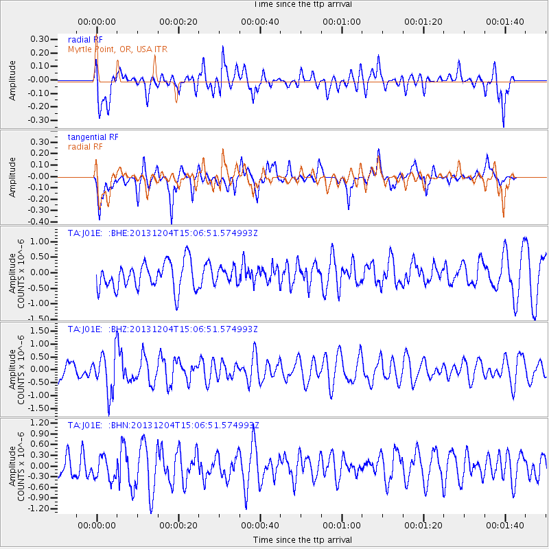
J01E Myrtle Point, OR, USA - Earthquake Result Viewer
*The percent match for this event was below the threshold and hence no stack was calculated.
| Earthquake location: |
South Of Fiji Islands |
| Earthquake latitude/longitude: |
-25.4/178.3 |
| Earthquake time(UTC): |
2013/12/04 (338) 14:55:40 GMT |
| Earthquake Depth: |
574 km |
| Earthquake Magnitude: |
5.7 MWW, 5.8 MWB, 5.8 MWC |
| Earthquake Catalog/Contributor: |
NEIC PDE/NEIC COMCAT |
|
| Network: |
TA USArray Transportable Network (new EarthScope stations) |
| Station: |
J01E Myrtle Point, OR, USA |
| Lat/Lon: |
43.16 N/123.93 W |
| Elevation: |
128 m |
|
| Distance: |
86.5 deg |
| Az: |
38.348 deg |
| Baz: |
230.05 deg |
| Ray Param: |
$rayparam |
*The percent match for this event was below the threshold and hence was not used in the summary stack. |
|
| Radial Match: |
53.116364 % |
| Radial Bump: |
400 |
| Transverse Match: |
57.261013 % |
| Transverse Bump: |
400 |
| SOD ConfigId: |
626651 |
| Insert Time: |
2014-04-19 23:19:52.868 +0000 |
| GWidth: |
2.5 |
| Max Bumps: |
400 |
| Tol: |
0.001 |
|
Signal To Noise
| Channel | StoN | STA | LTA |
| TA:J01E: :BHZ:20131204T15:06:51.574993Z | 2.4407313 | 8.055038E-7 | 3.3002559E-7 |
| TA:J01E: :BHN:20131204T15:06:51.574993Z | 1.0471108 | 3.5080063E-7 | 3.350177E-7 |
| TA:J01E: :BHE:20131204T15:06:51.574993Z | 0.55314225 | 2.3985277E-7 | 4.3361862E-7 |
| Arrivals |
| Ps | |
| PpPs | |
| PsPs/PpSs | |


